Early
Partial Views: Shakespeare and the Map of Ireland
Bernhard Klein
University of Dortmund
klein@mail.fb15.uni-dortmund.de

Klein, Bernhard. "Partial Views: Shakespeare and the Map of Ireland." Early Modern Literary Studies 4.2 / Special Issue 3 (September, 1998): 5.1-20 <URL: http://purl.oclc.org/emls/04-2/kleipart.htm>.

I
  1. Maps "work," writes Denis Wood, because they "give us reality, a reality that exceeds our vision, our reach, the span of our days, a reality we achieve no other way."[1] They manage, that is, to pass off for evident truth what is hard won, culturally acquired knowledge about the world we inhabit; a reality unverifiable by the naked eye: by making us see what eludes our visual perception, by dragging into open view literally invisible spaces, maps promise with each line to transcend the limited powers of human eyesight. The sense of privileged visibility intrinsic to cartographic representation elicited many enthusiastic responses from early modern commentators. "[S]tudy well these moderne Maps," Thomas Blundeville recommended in 1589, "and with your eie you shall beholde, not onely the whole world at one view, but also euery particular place contained therein."[2] The generic labels of contemporary atlases, such as the "glass," the "mirror," or the "speculum," equally foregrounded ocular effects; and when Abraham Ortelius, in the preface of his bestselling world atlas Theatrum Orbis Terrarum, called geography"the eye of History"[3] he referred directly to the visual power of maps and their ability to expand the perceptive faculties otherwise limited by the restraints of space and time.

  2.  
  3. Yet if only to exploit a well known metaphor, it should be noted that some eyes are as blind as others are observant, and contemporaries also recognised that the abstraction of geometric scale may quietly conceal rather than openly disclose geographical information. Trust in the usefulness of maps as visual tools was never as unconditional as the familiar tone of Blundeville's eulogy makes it appear. Samuel Daniel, for instance, took the opposite stand when he judged maps to be indistinct and literally superficial images of space: "We must not looke vpon the immense course of times past," he explained in his Defence of Ryme (1603), "as men ouer-looke spacious and wide countries, from off high Mountaines, and are neuer the neere to iudge the true Nature of the soyle, or the particular syte and face of those territories they see. Nor must we thinke, viewing the superficiall figure of a region in a Mappe that wee knowe straight the fashion and place as it is."[4] For Daniel, maps are insufficiently detailed and wrongly focused records of space, vague approximations at best, which concentrate exclusively on the outward "figure," not the inner quality, of landscape. They are, in fact, instruments of a worrying delusion which may effectively prevent visual access to vital information by keeping the viewer at a distance from the"reality" of the region depicted, from the "fashion and place as it is."

  4.  
  5. The distinction set up here, between maps as either completely revelatory or conceptually blurred images of landscape, should come as no surprise. It is hard to dispute that maps indeed manage to style themselves as instruments of unlimited ocular inspection, but only after they have first simplified their mode of pictorial composition and selected only certain bits of spatial information as worthy of representation; it is this dual process of internal revision which allows them to convincingly imitate what they casually refer to as the "real." On the content level, in the choice of what landscape elements to include in the visual display, the "prior editing"[5] of the cartographic picture plane is most clearly noticeable; and these "superficial" reductions in spatial complexity are repeated on the level of representational technique. Edward Worsop, a contemporary English land surveyor, explained that cartographers simply cannot be expected to convey an "accurate" impression of landscape since they are exclusively concerned with "the vpper face of any thing," "desir[ing] only to know the content of the outward plaine . . . not regarding thicknes, weight, grossenes, or depth: but only the mesure of ye vpper parts as in groundes: which consist onely of length, and bredth, whether they be flats, or leuels, hils, or valleis."[6] Nevertheless, it is such exercises in graphic minimalism which managed to generate the telescopic fantasy of a fully accessible world where, in the words of Arthur Hopton, "in a faire and most perspicuous light, / The earthy Globe lies subiect to thy sight."[7] Evidently, to call a map a selective vision of space endowed with the unique ability to feign a comprehensive and complete image of "reality" is not to accuse maps of a secret manipulative power but merely to comment on a constitutive aspect of cartographic projection.

  6.  
  7. In the essay that follows I will consider the operation (and political functionalization) of this visual code in one specific historical instance, the English construction of Irish space in a series of Elizabethan and Jacobean maps. On these maps, the representational tension between cartography's claim to universality and its necessary partiality generates a pictorial dialectic between visibility and shadow that is manifest both in the parergonal matter and the actual geographical content of the map image. Most extant contemporary English maps of Ireland, it should be noted, do little to hide their involvement in the colonial politics of their historical moment. In gradually redefining the "savage" Irish wasteland as a territorial extension of the national sphere, they are quite openly engaged in negotiating the political accommodation of Irish cultural difference into a British framework. But what may appear as a one-directional colonial practice was never simply a straightforward process of political appropriation articulated in cartography: while offering to deny, and thus implicitly claiming to have mastered, what many English observers rationalized as Ireland's intractable spatial "otherness," maps also needed to affirm the "reality" of this discourse in order to legitimate their complicity with England's destructive military action. Maps, I will argue below, are suggestive records of such tensions but they never exist in isolation, and while they could produce a variety of different statements regarding the relationship between Ireland and England, a similar visual code generates the fluid spatial imagery prevalent in dramatic representations of the "saluage Iland."[8] It is this discursive connection between the literary and the cartographic I intend to explore by linking contemporary maps of Ireland to one of the prime textual sites that gives aesthetic resonance to the Anglo-Irish confrontation of the 16th century, the plays of Shakespeare.

  8.  


    II
     

  9. The spatial ambivalence of England's neighbouring territories is demonstrated by the slippages that could occur in contemporary references to national geography. In John of Gaunt's vision of a "sceptred isle,"[9] perhaps the locus classicus of such geographical distortions, divine favour and cartographic vision combine to produce the "island" of England as a "blessed plot" (II, i, 50), effacing all traces of Scots and Welsh. In a gesture at once more expansive and even less interested in geographical fact, William Cuningham declared in his Cosmographical Glasse that "vnder the name of Englande, I comprehende the whole Ilande conteyning also Schotlande, & Irelande"[10] -- a memorable passage in a book entirely concerned with technical precision in measuring land, reading the sky and producing accurate maps. Cuningham's casual reference to an all-inclusive English insularity hardly echoes widely shared assumptions about Britain's physical topography but indicates both the imaginary potential and the political relevance of early modern geographical thought. Elsewhere in contemporary discourse the definition of Ireland's status with respect to the national territory was an infinitely more problematic issue. Perceived as culturally distant and physically inaccessible, both by government officials and professional cartographers, Ireland continued to elude English military and discursive control in Elizabethan times. Maps reflect this incomplete conquest: even where an uninterrupted line encloses the entire island, suggesting full cognitive possession of the space it circumscribes, the visual and conceptual coherence of the pictorial surface is never fully achieved. Similarly, on the Elizabethan stage, Ireland is rarely more than a shadowy and indistinct background of the dramatic scenery, always only partially coming into view. In what follows I will explore this interrelation of dramatic and cartographic imagery in two steps -- first, by considering a set of references to Ireland in four plays by Shakespeare; and second, by concentrating on the descriptive visual strategies of early modern maps of Ireland.

  10.  
  11. Although the representation of Ireland in Shakespeare is hardly more than indirect and fragmentary, a number of plays, specifically an early comedy and three of the English histories, invest to different degrees in the image of a nebulous territory beyond the porous borders of the national sphere, at once confirming, and posing a threat to, England's cultural integrity. A passage in the Comedy of Errors (c. 1594) opens the set of references to Ireland in the Shakespearean canon. In Act 3, a comic exchange between Dromio and Antipholus of Syracuse is structured around the image of a terrestial globe. Prompted by Antipholus, Dromio practises his misogyny on the kitchen maid Nell: "She is spherical, like a globe. I could find out countries in her." "In what part of her body stands Ireland?" "Marry, sir, in her buttocks. I found it out by the bogs." (III, ii, 113-7) Dromio proceeds to allocate different countries to parts of Nell's body: he discovers Scotland in the barren palm of her hand; France in her warlike forehead; England in the chalky cliffs of her teeth; Spain in her hot breath; the Indies in the carbuncles on her nose. "Where stood Belgia, the Netherlands?" "Oh sir, I did not look so low." (136-7) Dromio's spatial fiction is enabled by the grotesque female body of Nell, serving as the external framework for a political geography of national stereotypes. Conflated with her body is the metaphorical paradigm of the globe, and by extension the map, inscribing a corporal topography with political and ethnographic meaning. Ireland is singled out for the only explicitly scatological reference -- a territorial cesspit and potential source of infection and disease.[11] A bodily hierarchy of high and low, clean and filthy, cultivated and repressed, is translated -- via cartographic imagery -- into a political relationship of cultural domination. In an Irish context the word "bog" has an additional resonance that exceeds the allusion to bodily hygiene and points to the wider context of English political anxiety centred on an impenetrable Irish landscape. For Edmund Spenser, Irish "bogs" are dark and threatening hiding-places, shelter of the monstrous Irish kern, "a flyinge enemye hidinge him self in woodes and bogges."[12]

  12.  
  13. In Shakespeare's English histories the symbolic space Ireland occupies in this early comedy gives way to a more direct engagement with its physical reality. In 2 Henry VI, a messenger arrives on stage with news of an uprising in Ireland.[13] York, who has just been seen plotting against Henry's ex-Protector Gloucester, is asked "to lead a band of men" (III, i, 312) into Ireland and crush the rebellion. York complies, but only to use this opportunity for his own plot against Henry. The soldiers in his charge turn into "sharp weapons in a madman's hands" (347) -- once in Ireland, their number will greatly increase through the addition of Irish mercenaries. The Irish rebellion is thus doubly contagious, materially amplifying armed conflict in England and physically spreading across the Irish Sea. The activities of York bring to a fatal climax the interdependence of events in England and Ireland: "Whiles I in Ireland nurse a mighty band, / I will stir up in England some black storm." (348-9) This black storm will be raised by Jack Cade, "a headstrong Kentishman" (356), employed to "make commotion" (358) in England during York's absence. Cade is well trained in Irish techniques of disguise -- York, under whom Cade used to serve in Ireland, recounts how he has often seen him spy among the native Irish in the appearance of a "shag-haired crafty kern" (367). The final act sees York's "army of Irish" (V, i, stage direction) briefly invade the stage as a prelude to the English king's defeat in battle. Thus, 2 Henry VI stages the Irish intervention in English politics as a highly complex and ambivalent affair. On the one hand, as Andrew Murphy has recently noted, the play skilfully recruits Irish otherness in the service of an internal English dispute over royal succession: York is in full control of his "army of Irish," Cade masters the specific Irish ability to switch identity at random. But although Ireland serves as "a source of English strength,"[14] at least for York, it is also a source of disaster, war and confusion. England's misfortunes are tied up with its involvement in Irish affairs: armed conflict is shown to be endemic to Ireland and spreads to England only through York's intervention; the English civil wars start with an army raised in Ireland that crosses a sea which should have served, according to John of Gaunt, as a defensive wall; and the internal rebellion of Cade is implicitly enabled by his adoption of what are generically Irish tactics. Thus, in analogy to the symbolic Ireland of the Comedy of Errors, very real dangers are shown to be emanating from its physical space.

  14.  
  15. In Richard II, Irish rebels are again causing political unrest, a situation that necessitates the king's personal intervention. But in contrast to the earlier play, Richard's Irish adventure invites catastrophic failure. Just prior to his return from Ireland his troops desert him and he subsequently loses the entire kingdom to Bolingbroke. Where York could gather military strength, Richard lost it. Ireland's physical territory remains vague and unspecific throughout the play -- a distant wilderness, a dark space looming beyond the confines of the dramatic scenery. As opposed to 2 Henry VI, the Irish are invisible, they have disappeared as actors, both from the stage and from the scene of English politics. In Henry V, written against the background of the very real rebellion of Hugh O'Neill, they reappear in the person of the Irish captain Macmorris. As an Irish soldier Macmorris now serves a legitimate English king, in contrast to the kerns and galloglasses brought on stage in 2 Henry VI. During the siege of Harfleur he famously erupts into a string of expletives, levelled at the Welsh captain Fluellen: "Ish a villain and a bastard and a knave and a rascal" (III, iii, 61-2). This outburst in the company of an English, a Scottish, and a Welsh captain, is framed by the double articulation of what has stubbornly remained, in centuries of Shakespeare criticism, an unanswerable question: "What ish my nation?" (III.iii, 61-2) By now a principal Shakespearean target of colonial discourse analysis, this brief scene has recently been the subject of various contrapuntal readings which attempt to reclaim Macmorris from his subsumption under the hegemony of English power, insisting that his cryptic remarks destabilize the terms and categories of the colonial discourse which produced them in the first place.[15] Such critical efforts highlight the crucial ambiguities of this scene but must still concede that Macmorris appears here in explicit support of an internal colonial project that was slowly taking shape when the play was written, the project of a unified Britain. That union is difficult to achieve, as the dramatic row testifies, but the scene nevertheless adumbrates a collective idea of Britishness, a largely fictional political space translated into the schematic quartet of the four captains.

  16.  
  17. Thus, in Shakespeare, Irish space is initially synonymous with a source of political unrest, a place from which rebellion may at any moment spread to England. It is a physical and political wilderness, a sinister "secrete skourge,"[16] destined to haunt England. In the Comedy of Errors, Ireland is constructed as a metaphorical territory of human and political waste. In 2 Henry VI and Richard II, Ireland meanders between presence and absence, visibility and shadow; and while it may only serve as a historical background to the drama of royal succession, it has a crucial impact on the turn of events. But in Henry V Ireland's agency seems notably contained, the "army of Irish" have been reduced to the character Macmorris and though random aggression still dominates Irish nature it now ultimately contributes to the successful English war effort. Read against the background of the Nine Years’ War, Macmorris’ irate question about his "nation" still reveals a fundamental anxiety about the nature of Irish identity and the uncanny Irish tendency, personified in the historical character Hugh O'Neill, to change sides whenever a convenient moment arises.[17] But this destabilizing effect is rendered less threatening through Ireland's political domestication, reflected in Macmorris' inclusion in Henry's army. In the political rhetoric of Jacobean England, Ireland increasingly gets assigned a fixed place within a national "British" framework, an imperial discourse resting on the expanded definition of a national territory encompassing the entire geographical area of the British Isles. Ireland may not be fully assimilated into this framework -- the Irish continue to speak deficient English, and start unnecessary rows -- but the scope for potential transgression inherent in earlier representations is significantly narrowed. On contemporary maps by English cartographers, I will argue in the next section, Ireland's visual (dis)appearance is organised along similar lines.

  18.  


    III
     

  19. In early modern England, cartography could serve eminently public functions. Christopher Saxton's maps of the English and Welsh counties, published in atlas form in 1579, allowed contemporaries for the first time to "[take] effective visual and conceptual possession of the physical kingdom in which they lived";[18] and John Speed's Jacobean atlas of 1611, The Theatre of the Empire of Great Britain, expanded this national vision to encompass a unified Britain, referred to in biblical hyperbole as "the very Eden of Europe."[19] This peaceful English "garden," however, was located in immediate proximity of an Irish "wilderness,"[20] and as contemporary English map-makers set out to define cartographically the space of the nation they were confronted with the "constitutional anomaly"[21] represented by Ireland: neither properly a kingdom nor fully a colony, its political status, and position within the national framework, was fraught with ambiguities. If maps are accepted not merely as records of contemporary geographical knowledge but also as pictorial sites on which the political and cultural shape of the nation was actively debated,[22] the extant cartographic evidence offers several models of how Ireland might relate to the national idea, varying from full integration to deliberate exclusion. Functionally related to the wider political arena in which they intervened, Irish maps are graphic evidence of the contradictory process by which Ireland's landscape could either be visually absorbed into the emerging political concept of national British unity, marked as a locus of cultural difference, or even ignored completely as a geographical insignificance located safely beyond the borders of the British mainland.

  20.  
  21. Maps have always been of immediate political interest and one of the earliest cartographic descriptions of Ireland that resulted directly from the state's increasing demand for maps as administrative tools was the Irish section on Laurence Nowell's General Description of England and Ireland (1564/5), "arguably the first map that cannot be regarded as essentially a derivation from the mid-fourteenth century "Gough" map of the British Isles."[23] Testifying to its political importance, the small pocket map (see Figure 1) survives in the one manuscript copy formerly owned by William Cecil, Elizabeth's chief minister, whose extensive annotations, spread profusely over the verso, trace various itineraries to the northern English counties and beyond to Scotland. The map covers the Scottish lowlands and the adjoining coastline of Flanders and France but is principally a representation of the entire territory of the Tudor state, including Ireland; it thus articulates what Steven Ellis has recently called, with reference to the earlier part of the century, the "collective view of the dominions which [the Tudor monarchs] ruled."[24] This is in itself an important political statement since large sections of the area covered by the map presented in fact, if not in official proclamation, considerable difficulties to the exercise of royal control. Cartographically, this political claim is sustained by the prominent display of the crowned Tudor Arms in the top left hand corner, matched on the right by a decorated title cartouche. Other ornamental additions include most prominently the portraits of two male figures in each of the bottom corners. The reclining figure on the left, visibly distressed and attacked by a baying hound, leans on a pedestal bearing a Greek inscription from Hesiod's Works and Days stating that after Pandora's opening of the jar "[h]ope was the only spirit that stayed there / in the unbreakable / closure of the jar, under its rim, / and could not fly forth."[25] The seated figure on the right, haughty and demanding in appearance, has a few books scattered about his feet and rests on an hourglass underneath which another inscription from Hesiod advises to "hope and endure."[26]

  22.  
  23. Usually identified as straightforward portraits of Nowell (left) and Cecil (right) these figures are frequently reduced in significance to a biographical footnote on the strain of a patronage relationship and thus isolated as properties of the cartographic image. Yet the pictorial arrangement, in my view, constitutes an integral whole whose semantic richness should not be effaced by dividing it up into several layers of signification, essentially unrelated to each other. By linking the cartographer and his patron to the title cartouche and the coat of arms, these decorative additions constitute a pictorial framing device that places the territory in the dual grip of royal supremacy and authorial intention. Read as allegories for the map's political and geographical content level the portraits are even more suggestive. Representing the two halves of an unequal political union between a superior England on the right and a dejected Ireland on the left, their respective attitudes are indicative of the political relationship between Britain's "core region" and its most recalcitrant outlying province, the stubbornly rebellious Ireland. In so far as both figures assume classic postures of melancholy, they amplify the English-Irish duality into a double state of dejection;[27] but it is the depressed stance of the cartographer, attacked by the bane of surveyors, a baying hound, which condenses into one image the English frustration with the canine Irish, perceived as savage and barbaric, over whose territory the seditious contents of Pandora's box hold sway at will. The cartographer's empty purse is as much an illustration of this mythological subtext as an allusion to the poor state of Nowell's finances and the squandered resources of Ireland. Thus, in its function as an address to the culture that produced it, Nowell's map does not simply reflect an "objective" sixteenth century perception of British and Irish geography but constructs an image of the internal dynamics of a political space which obliquely, through the use of textual and visual ornamentation, acknowledges cultural difference as a defining characteristic of the Tudor state.

  24.  
  25. English attitudes towards Ireland in the sixteenth century were increasingly marked by the contradiction between the insistence on absolute Irish otherness, rationalized as a fundamental incivility, and the need to assimilate the island into some sort of national framework on account of the political danger resulting from its geographical proximity. As Michael Neill has recently noted, "[w]hile the ideology of national difference required that the Irish be kept at a distance and stigmatized as a barbaric Other, the practicalities of English policy more and more pressingly required that Ireland be absorbed within the boundaries of the nation-state."[28] This conflict is registered on Nowell's map in the cartographic contours of Britain and Ireland which are implicated, to borrow a phrase from John Gillies, in a "semiosis of desire."[29] On the first printed map of the British Isles by George Lily, published 1548 in Rome (see Figure 2), Britain still owes its upright shape partly to the medieval tradition of the "Gough" map. Flanked on its western shore by an oddly-shaped smaller island that does not really seem to belong there, it adheres to a perfectly straight line from south to north and stands erect if the map (which has south to the left) is turned to suit our viewing conventions. But Nowell's Britain visibly curves westward as if to bend over and encircle its neighbouring isle. The political statement of the map -- the description of a space that aspires to the collective vision of a fully anglicized terrain -- is thus translated into an almost physical incorporation of those areas which, viewed from the English centre of power, constitute the outlying regions of an unevenly structured polity, the culturally diverse margins of the Tudor state. Yet the image of Ireland disputes this scenario by visually resisting such geographical appropriation. Large clusters of green suggest the intractability of a wild and barbaric landscape, its rough texture spells out the absence of spatial order. Pulled westward by the dynamism of the cartographic shape the viewer's gaze centres not on the dense toponymic surface of England but on the graphic irregularities and textual gaps of an "unfinished" Ireland, acting as the constant reminder of the incomplete conquest. The map's temporal code -- the memento mori of the hourglass, the plea to "hope and endure" -- further supports this reading by consigning to the future the uncertain political and cultural unity of the area Nowell describes, in an extant letter to Cecil (later Lord Burghley), as "regionem nostram" -- our region.[30]

  26.  
  27. Although Burghley was reputed to have "carried this map always about him"[31] the General Description remained in manuscript and Nowell does not seem to have been encouraged to embark on the larger project he outlined in his letter of June 1563: to produce a series of individual maps covering the entire space of "our region."[32] It may be that Burghley merely hesitated for a decade before the maps were eventually commissioned from another, possibly better skilled cartographer, Christopher Saxton. This traditional hypothesis is borne out by the sequence of events: Saxton began mapping England and Wales in 1574 and over the next five years duly compiled what Nowell may have been the first to envision, an English national atlas. Saxton's version of national space, however, varied considerably from that of his predecessor, both in its internal configuration and, more obviously, in its external shape. Judging from the General Description the geographical and cultural area indicated by "our region" hardly coincides with the limited scope of Saxton's Anglia (see Figure 3). In marked contrast to Nowell's map, Anglia conceives of England and Wales as an entity unto itself. Relegated to the margins of the image are fragments of Scotland, Ireland and France. If the General Description visually records a network of regional and political difference - emphasised by the prominent inclusion of Ireland, the itineraries to Scotland noted on the verso, the diversity of its linguistic code -- Saxton's Anglia shares in a different cultural agenda. Restricting ocular access to England and Wales the map subscribes to a narrower, more selective vision of the national territory but achieves in turn a degree of graphic consistency largely absent from the complex cultural patchwork Nowell's map inscribes on the natural geography of the British Isles.

  28.  
  29. It was not until the end of the century that the first single map of Ireland came off an English press. This was Baptista Boazio's Irelande (see Figure 4), a highly decorative map which owes much to earlier efforts, particularly to Mercator's version printed four years previously. Now commonly dated to 1599, the map has recently not met with much approval on the part of historians of cartography. Undoubtedly an example of accomplished craftsmanship, its lavish ornamental flourish, the purely fictional character of some of the map's topographical details and -- if one can generalize from the British Library copy of the map -- the extravagant use of colour, are all features that suggest that precise geographical information was not the map's principal objective. Both Boazio, the cartographer, and Elstrack, his engraver, are doubly present on the map: while two cartouches bearing their names signal directly their claim to authorship, a more imaginative but deeply colonial gesture transforms them into the toponyms Baptiste's Rock (off the Antrim Coast) and Elstrake's Isle (south-west of Tyrconnell). This inventive way of writing cartographer and engraver into Ireland's geography has led one commentator to suggest that the map "is not a good one, even by contemporary standards: obsolete before it was published . . . its geographical content is badly garbled and in places totally ficticious."[33] Such a view, though factually correct, implicitly assumes that the gradual increase of cartographic accuracy should be seen as the guiding principle of map history. But what makes Boazio's map such an important example of the way 16th century Englishmen made spatial sense of the intractable and "barbarous" Irish territory is precisely its value as a decorative image of Ireland's geography fluctuating between fact and fiction. Its purpose was not accuracy but opulent display. Boazio's and Elstrack's names function as a kind of geographical signature, an eccentric gesture perhaps,[34] but one that capitalizes on Ireland's status as the property of those that give it visual and verbal presence in maps and texts.

  30.  
  31. Nowell's Ireland, as I have argued above, oscillates between its status as alien other and as an integral part of the national landscape. Cartographically represented as England's object of desire, it eludes English discursive control, causing in response the resigned posture of "hope and endurance." Three decades later Boazio's image suggests a hardening of attitudes but still retains marks of these anxieties. The surface of the map forcefully articulates the claim to English supremacy over Irish soil: lavishly spread out over the entire canvas, Ireland is surrounded by symbols of English domination -- St. George's flag at the top, two majestic English ships sailing the Irish coastline, a dedicatory address to the queen in the bottom left-hand corner crowned by the royal coat of arms. In the dedication, the "loyall" cartographer hands both land and map to the English monarch, inviting her -- in a reverential gesture reminiscent of Blundeville's exuberant praise quoted at the outset of this essay -- to "distinckly see" the whole island with all its "Hauens, Rockes, sandes [and] Townes." Additionally, almost the entire country is densely covered with English place-names and the names of the larger landowning families. In the left hand margin we even find a brief English-Gaelic dictionary helping us to decipher Ireland's awkward, foreign-sounding place-names. By having successfully transferred the particular landscape of Ireland into an image implying an English conception of land ownership and using a standardized representational code, local knowledge no longer seems to matter: via its cartographic representation the impenetrable Irish landscape has become readable, the terrain "[removed] from the cognitive ownership of those who inhabit it."[35]

  32.  
  33. In terms of the map's visual language, however, this act of appropriation is incomplete: north-west Ulster -- disproportional, oversized, and equipped with a largely fictional coastline -- is still predominantly a toponymic void, lacking the proprietary tags spread over the rest of the map. These silences and empty spaces in the midst of what is otherwise a "garrulous" cartographic surface signify more than just technical difficulties in procuring reliable topographical data. Rather, shape and texture of this unscripted and inflated corner of the map are the result of anxieties about Irish "savagery" projected into the physical geography. An earlier Irish map gives further substance to this claim, a map closer to Nowell than to Boazio: John Goghe's Hibernia of 1567.[36]
  34.   On this map, in the same north-west corner of Ulster, three figures in full military gear visibly guard the terrain, preventing both physical and visual access to the land. These are depictions of Irish warriors, the notorious galloglasses, who keep the terrain beyond English reach. Their appearance on the image offers a striking parallel between dramatic and cartographic representations of Ireland: on Goghe's map, Irish galloglasses enter the visual field of the cartographic display; in 2 Henry VI, they enter the visual field of the Shakespearean stage. As a pictorial memento of active native resistance -- which literally disappears from view on Boazio's map -- the inclusion of these galloglasses both betrays English anxieties about this region and acknowledges military conquest as a necessary precondition for Ireland's full anglicisation, a political vision eventually given cartographic articulation in John Speed's Jacobean atlas, The Theatre of the Empire of Great Britain (1611).

  35.  
  36. The Kingdome of Irland (see Figure 5), the Irish map Speed included in his atlas, subscribes to the same national vision as the four captains scene in Henry V. Reflecting a new political order, this map enjoyed a far higher distribution than any of its precursors and became the standard representation of Ireland for the first half of the 17th century. English military triumph had cleared the ground for the cartographic conquest. In the intervening years since the publication of Boazio's map Hugh O'Neill had been finally defeated by the English general Mountjoy, the successor of the luckless Essex whose ill-fated Irish campaign is alluded to several times in Henry V. After decades of intermittent warfare, the whole of Ireland was now under full English military and political control. Accordingly, Speed's atlas can present Ireland as an integral part of the "empire of Great Britain": if Boazio's map of 1599 only implicitly suggested that colonial Ireland partakes in some vague way of a larger national British territory, this myth of spatial integration becomes the governing statement not only of Speed's Irish map, but of his entire atlas. Graphically, The Kingdome of Irland portrays a neat and perfectly controlled area, a peaceful and quiet expanse. A systematic toponymic structure provides a coherent representational pattern absent from all previous Irish maps. Marking its spatial subjection to English law, Ireland is safely subdivided into 32 counties;[37] and although the inaccuracies regarding the coastline of north-west Ulster persist, the pictorial surface of the map achieves both homogeneity and balance, suggesting a spatial harmony devoid of conflict. Ireland emerges as a well-balanced synthesis of space, a flawless unity of landscape. Reminiscent in colour and texture of Speed's own map of England, it proves to be a perfectly "natural" geographical extension of "Great Britain."

  37.  
  38. Yet the six portraits Speed places to the left of the map introduce an element of tension that challenges the image of peaceful coexistence. These portraits include the "gentle man and woman of Ireland," the "civil Irish man and woman" and the "wild Irish man and woman" -- all wearing the infamous Irish mantle, frequently the object of sharp English criticism.[38] The last entry on this pictorial list defines Irish space most unambiguously as a locus of cultural difference. Disputing the visual harmony of Speed's paper landscape, the "wild men and women" nestling in the margins of the map are visible signs of Irish "otherness," occupying the lowest cultural level in the entire Theatre and thus offering an oppositional agenda to the dominant plot of tranquil geographical proximity. But they also imply a degree of sameness, a worrying Anglo-Irish proximity, since on his map of England (see Figure 6) Speed employed an analogous device when he included eight portraits that broke down English society into individual social categories -- gentry and nobility, citizens and countrypeople. On both maps the people are "mapped" alongside the land they inhabit; in both cases they are separated from the land by being placed in a classic decorative arcade. But these similarities concern the frame of the image, not its contents; and thus only serve to hide the significant switch from the register of social rank employed on the map of England to the divisive and "proto-anthropological" argument of civility and wildness depicted on the Irish map. To suggest that the similarity of representational features implies an absence of cultural difference within the "empire of Great Britain" is surely to misread both the specific ethnographic argument of "wildness" -- a self-authenticating device defining not the "wildness" of others but the "civility" of the speaker --[39] and the immediate cartographic context of the portraits. Speed can parade the signs of Irish "otherness" -- the mantle, the spear carried by the "wild man" -- because the map ultimately subjects its social script to the discursive control exercised over Ireland's topography: in analogy to the military discipline of Henry's army, mastering even the violent temper of Macmorris, the ordered space of Speed's map does not tolerate the unrestricted movement of "wild men and women." The pictorial reminder of Irish barbarism serves not as an image of harmony but as a figure of enforced integration, suggesting the successful containment of Irish savagery.


  39.  


    IV
     

  40. Viewed in historical sequence, the series of Irish maps discussed in this essay serves as a sensitive cartographic register of the violent transfer of political authority in Ireland from native Irish to English colonizers. The "wild men and women" on Speed's Irish map gesture at the historical outcome of this political struggle for which the calm and decorative scenario of the map design served as the venue. In contrast to the openly defiant galloglasses on Goghe's map the Irish no longer roam the wild landscape at will but are safely accommodated into a pictorial framework visualising Ireland's political subjugation. On maps, as on the stage, Ireland eventually moves from its shadowy location in threatening geographical proximity to its visible inclusion in the spatial unity of a larger territorial setting. In an imaginative displacement Goghe's galloglasses are forced off the map and wander first into Boazio's visual void, and then to the margins of the map to be contained in the pictorial frame of Speed's portraits. Similarly, the "army of Irish" Shakespeare brings on stage in 2 Henry VI recede into the shadowy background of Richard II, and finally metamorphose into Macmorris, an Irish soldier safely contained in another territorial framework, the "British" army of an English king. In pointing out these conceptual affinities between dramatic and cartographic representations of Ireland I want neither to claim direct mimetic congruences nor suggest conscious authorial intentions. The temporal disjunctions and generic differences between various scenes written for the London stage during the decade of the 1590s and a series of maps spanning half a century of cartographic activity from 1564 to 1611 surely do not offer the coherent body of historical evidence a straightforward comparison would require. But I would like to suggest that the transmission of the cartographic image of Ireland from Nowell and Goghe through Boazio to Speed follows the logic of a trajectory observable also in the fragmentary representation of Ireland in Shakespeare -- a logic that increasingly attempts to contain Irish cultural difference in a "British" framework. Ireland's threatening otherness cannot be completely erased -- its overt and discreet manifestations continue to be present in all the visual and verbal examples I have looked at in this essay -- but it can be reduced in meaning to an instance of local peculiarity. The similarity of discursive movements in the representation of space signified as "Irish," circumscribing a conceptual triad of menacing presence, forced absence and guarded inclusion, is evidence of a continuous reflection on the link between people and land, pervading geographical thought, cartographic practice and literary discourse alike. Contemporary maps, visually recording or denying the knowledge of people and place, remain key representational sites for the critical inquiry into the nature of social and political space.
Notes
1. Denis Wood, The Power of Maps (London: Routledge, 1993) 4-5. [Back]

2. Thomas Blundeville, A Briefe Description of Vniversal Mappes and Cardes (London: T. Cadman, 1589) sig. C4r.[Back]

3. Abraham Ortelius, Theatre of the Whole World (London: John Norton and John Bill, 1606) preface (my italics).[Back]

4. Samuel Daniel, A Defence of Ryme (London: Edward Blount, 1603) sig. G.4.r. [Back]

5. The Power of Maps 72.[Back]

6. Edward Worsop, A Discouerie of sundrie errours and faults daily committed by Landemeaters, ignorante of Arithemtike and Geometrie (London: G. Seton, 1582) sig. B4r.[Back]

7. Arthur Hopton, Speculum Topographicum: or the Topographicall Glasse [1611] The English Experience 669 (Amsterdam: Da Capo, 1974) sig. a2v. [Back]

8. Edmund Spenser, The Faerie Queene ed. A. C. Hamilton (London: Longman, 1977) 5.11.39. [Back]

9. William Shakespeare, Richard II 2.1.40. This and all further citations from Shakespeare are to Stephen Greenblatt ed. The Norton Shakespeare (New York: Norton, 1997). [Back]

10. William Cuningham, The Cosmographical Glasse (London: John Day, 1559) 119 (my italics). [Back]

11. Andrew Hadfield suggests the influence of John Derricke's Image of Ireland [1581]. Cf. "Shakespeare, John Derricke, and Ireland: The Comedy of Errors, 3.2.105-6" Notes and Queries 242.1 (1997): 53-4. [Back]

12. Edmund Spenser, A View of the Present State of Ireland, ed. R.F. Gottfried, Spenser: A Variorum Edition Vol. 10: The Prose Works (Baltimore: Johns Hopkins Press, 1949) 3061-2. [Back]

13. For a thorough historical contextualisation of the Irish references in this play see Christopher Highley, Shakespeare, Spenser, and the Crisis in Ireland (Cambridge: Cambridge UP, 1997) 40-66. Highley argues that "Shakespeare weaves into the play a provocative and deeply conflicted analysis of the threats and and stereotypes associated with Ireland" (42). [Back]

14. Andrew Murphy, "Shakespeare's Irish History," Literature and History, third ser. 5 (1996): 46. [Back]

15. See David J. Baker, "'Wildehirissheman': Colonialist Representation in Henry V," English Literary Renaissance 22 (1992): 37-61. See also Shakespeare, Spenser, and the Crisis in Ireland 145-7. [Back]

16. Spenser, View 14. [Back]

17. "Shakespeare's Irish History" 40-2. [Back]

18. Richard Helgerson, Forms of Nationhood: The Elizabethan Writing of England, chapter 3: "The Land Speaks" (Chicago: Chicago UP, 1992) 107. [Back]

19. John Speed, The Theatre of the Empire of Great Britaine (London: Iohn Sudbury & George Humble, 1611) sig. B2v. [Back]

20. See Michael Neill, "Broken English and Broken Irish: Nation, Language, and the Optic of Power in Shakespeare's Histories," Shakespeare Quarterly 45 (1994): 10-18. [Back]

21. Ciaran Brady and David Gillespie, "Introduction", Natives and Newcomers: The Making of Irish Colonial Society, 1534-1641 (Dublin: Irish Academic, 1986) 17. [Back]

22. I develop this point at greater length with reference to England in "Constructing the Space of the Nation: Geography, Maps, and the Discovery of Britain in the Early Modern Period," Journal for the Study of British Cultures 4.1-2 (1997): 11-29, special issue, "The Discovery of Britain" ed. Manfred Pfister. [Back]

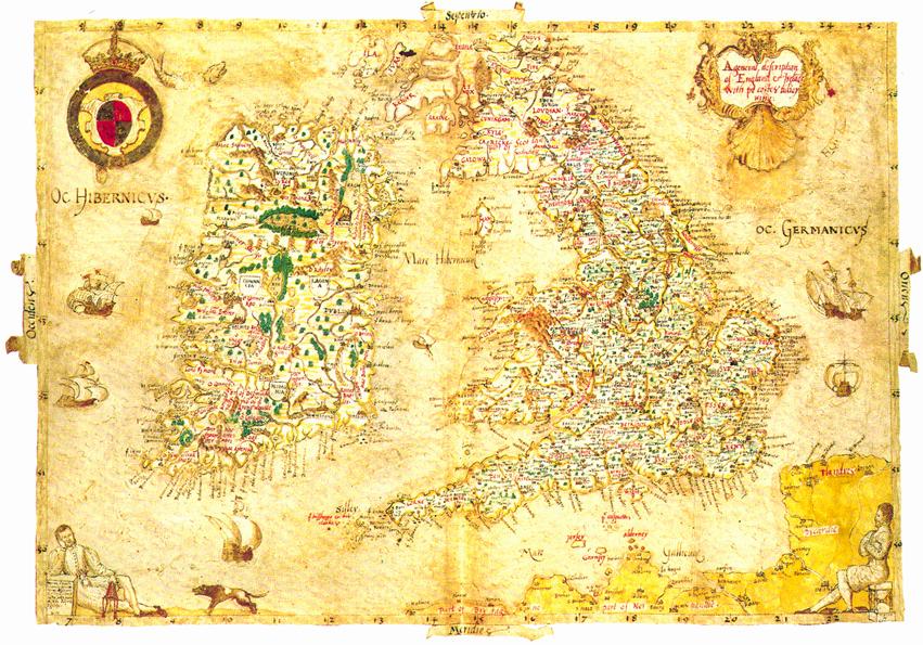
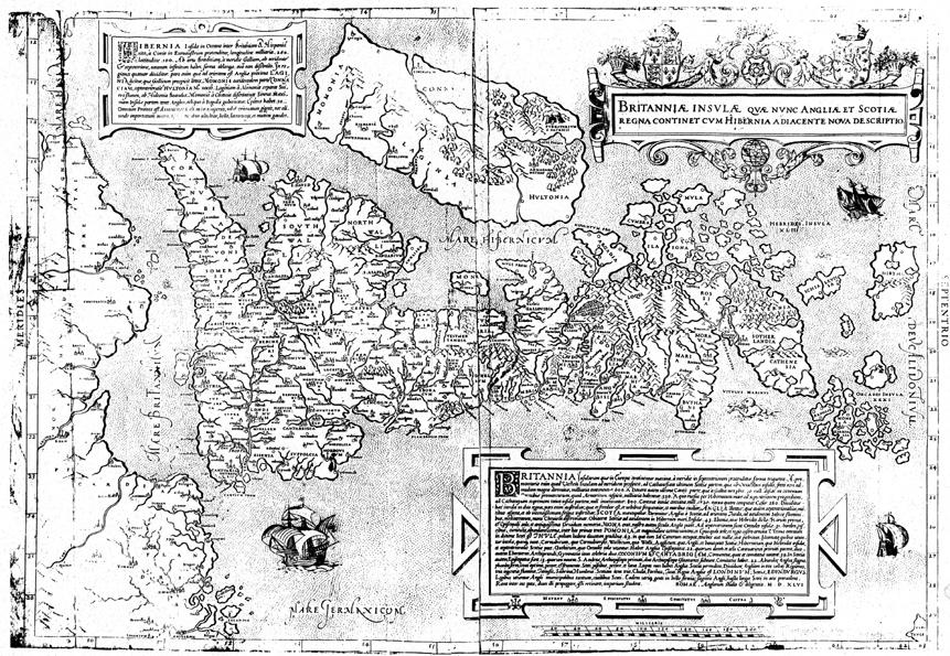
23. Peter Barber, "A Tudor Mystery: Laurence Nowell's Map of England and Ireland," The Map Collector 22 (1983): 19. The "Gough" Map, named after its 18th-century owner Richard Gough and now at the Bodleian Library, Oxford, is a 14th century map of Britain that considerably influenced later maps of the British Isles, including the1569 Mercator version. [Back]

24. Steven G. Ellis, Tudor Frontiers and Noble Power: The Making of the British State (Oxford: Clarendon, 1995) ix.  Thanks are due to the British Library for permission to reproduce the illustrations. [Back]

25. Hesiod, Works and Days, Theogony, The Shield of Herakles, Richard Lattimore, trans. [1959] (Ann Arbour: U of Michigan P, 1991) 29. [Back]

26. The Greek inscriptions are identified in Robin Flower, "Laurence Nowell and The Discovery of England in Tudor Times," Proceedings of the British Academy 21 (1935): 62. Flower's essay is still the best introduction to Nowell's life and work. For more specific historical information on the map see Barber, "A Tudor Mystery" and "The Minister Put His Mind on the Map," The British Museum Society Bulletin 43 (1983): 18-9. [Back]

27. I owe this point to Eckhard Lobsien. [Back]

28. "Broken English and Broken Irish" 3. [Back]

29. John Gillies, Shakespeare and the Geography of Difference (Cambridge: Cambridge UP 1994) 62. [Back]

30. Quoted from the original letter printed in Sir Henry Ellis, ed. Original Letters of Eminent Literary Men of the Sixteenth, Seventeenth and Eighteenth Centuries (London: Camden Society, 1843) 23. [Back]

31. Handwritten inscription (dating from the eighteenth century) on the front cover of the small notebook containing Nowell's map (Brit. Lib. Add. MS. 62540). Barber briefly discusses the likelihood of this conjecture in "Minister." [Back]

32. "A Tudor Mystery." [Back]

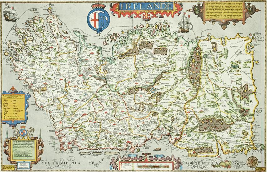
33. J.H. Andrews, "Baptista Boazio's Map of Ireland," Long Room 1 (1970): 29. Andrews' recent book-length study of Irish maps continues this line of argument and prefers to discuss not Boazio's map but his sources, the Irish surveys of Robert Lythe. See Shapes of Ireland: Maps and Their Makers, 1564-1839 (Dublin: Geography Publications, 1997) ch. 3: "'Baptiste's Isle': Baptista Boazio, 1599," 57-88.[Back]

34. But one fairly common in cosmographical works as, for instance, the two ominous "Thevet's islands" in French cosmographer André Thevet's unfinished Grand Insulaire et Pilotage (1586/7) indicate. [Back]

35.  Mary Hamer, "Putting Ireland on the Map", Textual Practice 3 (1989): 184. Hamer’s essay deals with a later mapping project in Ireland, the Ordnance Survey. [Back]

36.  This manuscript map is held in the PRO Kew as item MPF 86.  Unfortunately, excessive charges on the part of the PRO made the inclusion of an illustration in this essay impossible.  The map has recently been reproduced in Mercedes Maroto Camino, "'Methinks I See an Evil Lurk Unespied': Visualizing Conquest in Spenser's A View of the Present State of Ireland," Spenser Studies 12 (1998): 179, and in Shapes of Ireland 43. [Back]

37. Extant copies of Speed’s Irish map frequently show an original colouring which foregrounds either the 32-county division, a relatively recent administrative accomplishment, or the four historical provinces.  [Back]

38.  The mantle is extensively denounced in Spenser, View, 1555-1651. See also Ann Rosalind Jones and Peter Stallybrass, "Dismantling Irena: The Sexualizing of Ireland in Early Modern England", Andrew Parker et al., eds, Nationalisms and Sexualities (New York & London: Routledge, 1992) 157-71. [Back]

39.  See Hayden White, "The Forms of Wildness: Archaeology of an Idea", Tropics of Discourse (Baltimore & London: Johns Hopkins Press, 1978) 150-82. [Back]

Works Cited

© 1998-, R.G. Siemens (Editor, EMLS).