Early
Significant Spaces in Edmund Spenser's View of the Present State of Ireland
Joanne Woolway Grenfell
Oriel College, Oxford
jw268@cus.cam.ac.uk

Woolway Grenfell, Joanne. "Significant Spaces in Edmund Spenser's View of the Present State of Ireland." Early Modern Literary Studies 4.2/Special Issue 3 (September,1998): 6:1-21<URL:http://purl.oclc.org/emls/04-2/woolsign.htm>.

  1. Complaining of the slippery nature of the nomadic native Irish, Spenser notes that,
  2. he is a flyinge enemye hidinge him self in woodes and bogges from whence he will not drawe forth but into some streighte passage or perilous forde wheare he knowes the Armie must nedes passe . . . There fore to seke him out that flittethe and followe him that cane hardlye be found weare vaine and botelesse: but I woulde devide my men in garrison vppon his Country in suche places as I shoulde thinke mighte most annoye him.[1]
    These constantly moving rebellious Irish are represented as having posed a threat to English rule in Ireland because their location could not be pinpointed and because their knowledge of wilderness areas was superior to that of their colonial occupiers. These factors were considered to be major stumbling blocks in the way of English control of Ireland and various English administrators in Ireland, including Spenser, responded by setting out plans for control of both the countryside and the Irish who populated it. With landscape as a locus of uncertainty and resistance, a politic response to these Irish problems was to come from careful geographical planning, and from the strategic use of geographic and spatial metaphors to answer the political, social, and cultural concerns of colonization. This paper sets out to explore the representation of some of these concerns in Spenser's work and in related contemporary map texts, to connect historical events and textual accounts of place, and to advance awareness of the historical and theoretical interrelation of methods of graphic and verbal representation.


    I


  3. Much of Spenser's discussion of the problems of Irish landscape seems to stem from first-hand experience. He knew, for example, from his time as Secretary to Lord Grey, that the Irish landscape had hindered inexperienced troops trying to fight the Irish. In 1580 in battle at Glenmalure against the rebel band of James Eustace, Viscount Baltinglass and Feagh MacHugh O'Byrne, Grey's men had been killed on the steep slopes of the South Wicklow mountains; easily visible to rebels hiding in the trees and boulders, the English soldiers had been slaughtered and their bodies had fallen down to the river below--the "balefull Oure, late staind with English blood."[2] The Irish had shown that they would defend their land fiercely, and it must have seemed obvious that in battle, knowing the layout of their areas, they would be at an advantage. Spenser had also seen that, if the English relaxed their defence of their towns and strongholds for a moment, the Irish would reappear from the wild areas to which they had retreated and would take over previously occupied areas. Passages in A Vewe record real examples of this recurring pattern even as far back as the time of division between the houses of York and Lancaster, when many of the English settlers had gone back to England to give assistance, defend their lands, or profit from events. As Irenius describes,
  4. This is one of the occasions by which all those Countries which lyinge neare to anye mountaines or Irishe desertes . . . were shortelye displanted and loste; as Namelye in Mounster all the lands adjoining vnto Slewlogher, Arlo and the bog of Allon, In Connaghte all the Countries borderinge vppon the Cullvers Moneroo and Orouks Countrie, In Leinster all the landes neighboringe vnto the mountaines of Glanmalor vnto Shillelah vnto the Briskelah and Polmonte In vlster all the Countries neare vnto Tirconell Torowne and ffertellah and the Skottes.[3]
    Whatever had been achieved through the careful planning, building, and fortifying of towns by the English in the years of their occupation had been undone by the lack of continual watch over and from these towns which had meant that the Irish could reclaim their territory. Out of sight, beyond the jurisdiction of English law, but not unaware of English movements in the country, the nomadic or isolated Irish continued to pose a threat to government control.
     
  5. In reality it was almost impossible for this situation to be changed. In 1600 about one eighth of Ireland was forest and these areas, along with the boglands, were both obstacles to English travellers or surveyors on government business and places of shelter for the dispersed native population.[4] According to John Dymmok's Treatice of Ireland some had been chopped down to try to remove shelter: he writes of the "great plenty of woods, except in Leinster, where for the great inconvenience, finding them to be ready harborures for the Irish rebell, they have beene cutt downe."[5] However, there were still vast areas that were unsafe to travel through. Efforts to improve this situation included the strengthening of roads and safe passages across wood and bogland which helped to ensure that travellers were not vulnerable to attack as they journeyed out from the several centres of English power, but this projected network was far from complete. In response, Spenser was particularly concerned that travellers should be channelled through established pathways and across controlled bridges, and that covered ways and the secret fording places of the Irish should be destroyed, so that all movement could be monitored. Irenius observes that
  6. the thefe theareby shall haue muche adoe firste to bringe forthe and afterwardes to drive his stollen praye but thoroughe the Comon highwaies wheare he shall sone be discried and mett withall and the rebell or open enemye if anie suche shall happen either at home or from abroade shall easelye be founde when he Comethe forthe and allsoe be well encountred withall by a fewe in so streight passages and stronge enclosures.[6]
    Contemporary cartographic texts show how this plan was visualized--a map of Leix and Offaly from circa 1565 shows "streighte" passages, picked out in black and red dotted lines, which were the safest ways through the green and brown shaded wild areas and across the strategically important rivers.[7] Despite these initial attempts to chart safe passages, Ireland was still only haphazardly mapped, with expert knowledge confined to limited parts, particularly those around Dublin and parts of Munster. On a nationwide level there had been no complete and comprehensive survey.[8] Consequently, it was not difficult for the Irish to live in areas which were outside of the knowledge of the English and outside of their sphere of influence.
     
  7. Geographical indeterminacy such as this had obvious social consequences as the Irish in the wild areas could also evade English law. In his perceptive study of legal subversion, David Baker has proposed that "what bothers Irenius is that the Irish can manoeuvre within the political boundaries of the common law and yet escape its jurisdiction."[9] This bending of the metaphorical boundaries of politics and the law seems partly to have been a result of geographical separation; the Irish had been able to move freely around the country and then retreat to areas outside English control after events such as the battle at Glenmalure, thus avoiding the punishment of English law. As geographically excluded from English settlement in Ireland as they were disenfranchised by English law, the Irish had no stake in the government of their country or in the development of Irish soil.[10] Indeed they had every incentive to use their knowledge of the inhospitable Irish landscape to tactical advantage.

  8.  
  9. With spatial freedom as a good indicator of power, it is not surprising that Spenser turned elsewhere to cartographic metaphors to represent the imposition of English social and cultural norms as a means of controlling the land. In discussion, for example, of that "Arch-Rebell," the Earl of Tyrone, Irenius draws on a cartographic vocabulary when he gives a possible reason for the Earl's continuing rebellion; he notes
  10. how harde it is for him now to frame himself to subieccion that having set once before his eyes the hope of a kingdome hath thearevnto founde not onely encoragement from the Greatest kinge of christendome, but allso founde greate faintens in her maiesties withstandinge him.[11]
    This notion of framing [12] -- suggesting the bending of individual characters to authority like the features of a landscape to the conventions of a map -- is interesting because it again reinforces cultural boundaries over geographical ones; that is, although events were taking place on the map of Ireland, they were subject to English cultural expectations. Those people living in that territory who did not allow themselves to be contained or subjected in such a way -- who lived physically and metaphorically outside English law, for example -- were perceived dangerous because they challenged the accepted frame of reference for social behaviour and political allegiance.[13] The importance of these spatial metaphors as indicators of anxiety about boundaries and cultural norms is also suggested by their use to refer to threats to English rule from within: that is, from the Old English in Ireland who might have been assumed to have shared the English administration's views, but who had sometimes become dangerously assimilated with the Irish. Using the same terms as Irenius had earlier chosen, Eudoxus criticizes the Old English, asking how they "shoulde so far growe out of frame that they shoulde in so shorte space quite forgett theire Countrie and theire owne names . . ."[14] With the reference to framing and to "short space" also calling to mind the scaled reduction of the map which Eudoxus unfolds, we can see how the use of mapping conventions in these instances hints at uncertainties in the field of colonial rule and in the geographical knowledge and representation which underpinned English power. Cartography, as a form of representation in its own right, and as an informing discourse in the overlapping area of political planning, must have seemed to have provided the tools with which to set up exclusionary boundaries and thus define otherness through the certainties of geographic segregation rather than through slippery notions of race and culture. In a colony where national and cultural identity were uncertain and where once certain differences had become blurred, these seemingly certain means of differentiating between races and cultures were prized.
     
  11. A similar correlation between lawlessness and geographical exclusion (or "otherness") is hinted at in the descriptive term "renegade" (or, more obviously, in Spenser's spelling of it as "runagates"[15] ), which encompassed apostates, deserters, fugitives, and runaways, as well as outlaws and others who found themselves outside the security of the town walls. Its root suggests a predominantly spatial and centralized conception of law, government, and of the relation of the individual to society. Indeed, I would argue that the conception of power and place put forward in these cartographic terms is part of a deliberate representational strategy on Spenser's part, intended to bring new terms to and a new way of looking at the indeterminate and difficult field of place, culture, and national identity. Critical attention has recently been drawn to the significance of Eudoxus' verbal unfolding of a map in the tract, and parallels have been drawn between the apparent drawing of English lines of power on the seemingly blank sheet of the map of Ireland, and the colonizing strategies of verbal texts such as Spenser's which seem to impose their "view" onto the page of Ireland's linguistically, culturally, and geographically unfamiliar terrain. I would argue that cartographic or spatial metaphors inform the language of the text more than has previously been realized, but also that the nature of the relationship between spatial and verbal representation has sometimes been misunderstood, and that, as a consequence, we have underestimated the extent to which A Vewe cleverly, but sometimes inconsistently or uncertainly, negotiates cartographic conventions to put forward a plan for the development of Ireland's significant spaces.

  12.  


    II


  13. The primary consideration in the discussion of texts of place is, therefore, the relationship between spatial representation and power. In writing about English colonialism in Ireland it is tempting to characterize cartography as a crude tool of colonial power, a medium favoured by government officials and writers because it allowed for the imposition of a certain English viewpoint onto a foreign place and encouraged the dehumanization of Ireland by turning the ambiguities and difficulties of colonial control over the Irish people into simple lines on a page. Recent criticism has tended to follow this interpretation, implicating geographic discourse in the colonial desire for power, stressing the monolithic nature of its viewpoint, and equating the graphic representation of territory on the blank page of the paper map with the often ruthless exploits in Ireland of the Elizabethan administration. Bruce Avery, for example, has suggested that after Irenius in A Vewe has unfolded his map, the characters limit themselves to putting forward an official, royal-sanctioned view of Ireland which is supported or even constrained by a unified geographic perspective. According to him, the chart of Ireland which Spenser's characters unfold "eliminates mythopoesis, the multiple perspectives among which Irenius had wavered. Thereafter he and Eudoxus view Ireland from the single perspective forced upon them by the map."[16] Other critics have assumed also that this single perspective is primarily a military or legal one: Julia Reinhard Lupton states that
  14. In A Vewe Eudoxus refers to 'the map of Irelande' in a military context. English maps of Ireland were almost always designed for military and legal purposes, in order to establish strategies of attack and defence, and in consolidating military success, to (re)determine the boundaries of property.[17]
    Whilst this is generally the case, examination of a range of contemporary maps reveals that other perspectives also prevailed; decorative town plans and more practical illustrations of projects of settlement and cultivation also figure strongly and, I would argue, provide an important context in which to see the presentation of Spenser's own proposals for the reform of Ireland.[18] Whilst cartographic texts undoubtedly show the English concern, shared by Spenser, to further by military means the English hold on Ireland, this was only part of the picture. Moreover, this picture was often characterized by competing viewpoints rather than by the supposedly single perspective of cartographic discourse which recent historical-theoretical criticism has taken as a defining feature. This is not to deny that the English were looking for an effective way of imposing their colonial power on Ireland, but it is to suggest that where cartography and spatial metaphors were used to achieve these aims, the very inconsistencies of contemporary cartographic convention were the powerful means through which English perspectives and visions of power were imprinted. Paradoxically, these inconsistencies were also the means by which English uncertainties about the strength and permanence of that power were revealed.
     
  15. Even leaving aside the obvious examples in A Vewe of the presentation of disagreement and opposing viewpoints (from the dialogue of Eudoxus and Irenius themselves, to the implied differences between the Queen, on the one hand, and Lord Grey and Spenser on the other), it is clear that mapping itself does not necessarily encourage one unified or militaristic perspective. Whilst contemporary Irish maps clearly do show the dominance of an English perspective in their representations of Ireland, they do not always privilege the fixed, regular, and geometric ordering of space which modern commentators sometimes characterize them as doing. That is, there are often several unreconcilable viewpoints or inconsistencies in contemporary representations of space. Not only are there several maps of the country in which information from different sources is put together to provide what is obviously an incomplete or distorted picture,[19] but there are also maps in which multiple scales and perspectives operate within the same frame. For example, BM Cotton MS Augustus i, ii ,55 is a map of "Gallaway", with a town plan in the centre, surrounded by rock, woodland, and sea. The precise geographical measurement of the map is suggested by compass lines which radiate from the edges of the town area almost to the corners of the map frame, showing the bearings of SE, SW, NW, NE; but, as the key explains, the map has peculiar dimensions in so far as it operates simultaneously on two distinct scales of measurement -- "The sircuite of the town of Gallaway one foute to the Inche, the county and baye about it a mille to a Inche." In other words, the part which is most significant to the English -- the town -- is mapped to a larger scale than the surrounding wilderness. Undeniably, therefore, the map privileges an English viewpoint, but what it also demonstrates is that maps do not only contain one fixed perspective which insists that geometric certainties are mapped onto landscape in the service of a colonial "plot."

  16.  
  17. Whilst the local detail of the map is only tangentially relevant to Spenser's plans, it is clear that the conventions by which it operates, and the practical purpose which informs the choice of these conventions, can be parallelled in prose texts. For not only does it draw attention to the complexity of different kinds of textual representations of space and the possibility that multiple strands of significance can be represented within one frame, but it also presents an appropriate illustration of the ways in which emphasis could be put on significant spaces in order to illustrate a plan for development. By significant spaces I mean those areas of Irish soil--towns, enclosures, fortifications, safe pathways -- over which Spenser knew the English had to gain control if they were to bring about their plans of settlement, cultivation, and reform. The symbolic function of these spaces is clear; they project a representation of the known, mapped English space as superior to the feared, Irish-controlled wilderness outside. But the practical element of this representation is also important: these spaces, particularly inside the walls of a fortified town, needed to be mapped to a larger scale to show how they could better be fortified and, eventually, developed. These methods are important to our understanding of the strategies of A Vewe for two reasons. First, the careful mapping of a town area exemplified in this and other similar maps, to which I will return, draws attention to the importance for the English of fortified towns which could be used as strongholds to keep watch on the countryside around, but which could also contain the beginnings of settlement and furnish space for the cultivation of the land. Second, the unusual scale and perspective of the map, with their symbolic and practical implications, provide a useful reminder that the symbolic is not always the dominating mode in discussions of colonial power -- i.e., that cartography and colonial writing are not symbolically dominated by hegemonic power operating through spatial representation but also operate on a functional level. In connecting Spenser's proposals for the development of towns with relevant town plans, I will suggest a different model for understanding the interrelation of spatial representations of place which will put more emphasis on the practical than has previously been allowed.

  18.  


    III


  19. A key passage in A Vewe is Irenius' delineation of a plan for the creation of fortified towns which would stand as centres of culture and civility, protecting settlement and agriculture around them. These towns would grow from existing forts around which a settlement would be
  20. layed forthe and encompassed, in the which I would wishe that theare should inhabitantes of all sortes as merchantes Artificers and husbandmen placed to whom theare shoulde Charters and franchises be graunted . . . so woulde it in shorte space turne those partes to greate Comoditye and bringe er longe to her maiestie much proffitte for those places are so fit for trade and traffick, havinge moste Conveniente outgates by ryvers to the sea and ingates to the richeste partes of the lande that they woule sone be enriched and mightelye enlarged, for the very seatinge of the garrisons by them besides the safetie and assurance which they shall worke vnto them will allsoe drawe thither store of people and trade as I haue sene ensampled at mariburgh and Philipstowne . . .[20]
    Not only does this description suggest that Spenser's plans are carefully modelled to fit the topography of the individual locations (their proximity to the sea, for example [21] ) but it also demonstrates how Spenser saw that the different stages of development could be linked within one site -- which had provision for living and working, an enclosure for cultivation or cattle keeping, and fortification to insulate the English from Irish attack or influence. Like the developed Albion in Book 2 of The Faerie Queene, Ireland in Spenser's view could also no longer be described as "Vnpeopled, vnmanurd, vnprou'd, vnpraysd."[22]
     
  21. Significantly, Spenser's proposal for cultural development through the establishment of towns grew out of an earlier development in Leix and Offaly which had defence as its primary aim. This background is revealed in references to the two Leinster towns, Marybrough and Philipstown, which were first built as part of the plantation developments in 1546-52.[23] These fortresses provided a model for Spenser of centres of English civility, combining cultivation within their walls with garrisons which could protect large areas around them from Irish raids. This was vital in the Leinster area because of the influence of the rebel Lord Feagh MacHugh Byrne, whose forces had overcome Lord Grey at Glenmalure in 1580. Spenser was aware of the strategically valuable position of his stronghold at Ballinecor, which had allowed O'Byrne to plunder some of the most civilized parts of Leinster and to give support to other rebels: he observes that "through the strengthe and greate fastenes of Glan malour which Adioyneth vnto his howsse of Ballinecorre, [O'Byrne] drewe vnto him manye theves and Outlawes which fledd vnto the succour of that glenne."[24] This rebel stronghold appears to have been a threat to English rule because it took power away from the English strongholds and undermined a plan of reform which relied on English centres of government and civilization being unthreatened or, if attacked, invincible. It is out of this simultaneously geographical and historical understanding that Spenser's plan for increased numbers of garrisons around O'Byrne's land was developed -- a plan which, as Rudolf Gottfried has explained,[25] involved surrounding and effectively stifling the outlaw by stationing six forces around his land, and planting garrisons at Knockelough, Arklow or Wicklow, Shillelagh, around Dublin, and at Talbotstown, Ballinecor, the Valley of Slaney, and, importantly, Marybrough, and Philipstown. This was intended to cut off O'Byrne from sources of support and form a protective shield around the southwestern side of the Pale. With English power dispersed to strategic points such as the towns of Marybrough and Philipstown, Spenser could hope to weaken the strength of the Irish who opposed English rule and who looked to alternative authorities for shelter or safe haven.

  22.  
  23. Spenser also saw that other towns could be built along similar lines: as Eudoxus proposes, "Indede me semes Three suche Townes as ye saie woulde doe verye well in those places with the garrissons and in shorte space woulde be so augmented as they woulde be hable with little helpe to enwall themseues stronglie."[26] Relying again on that little phrase "in short space" which seems to refer primarily to temporal space but which frequently appears when the text moves into a cartographic or generally spatial register, Eudoxus uses his geographical knowledge to lay out a network of government for Ireland in which centres of command are dispersed across the country.

  24.  
  25. The question of the degree of independence of these towns -- sea-ports and inland garrisons -- inadvertently gives a clue as to some of the conflicts between the English administration in Ireland and the English government in England. The towns seem to have been planned in such terms as make it clear that, in a typical colonial centralizing strategy, they would refer back constantly to the royal power in England. This strategy was also not without its difficulties: the names of Marybrough and Philipstown, changed from the Irish during the reigns of Mary and Philip,[27] simultaneously referred back to a firm centre of English monarchical authority and drew attention to both England and Ireland's Roman Catholic heritage and connections with Spain -- connections which the English would have prefered to have de-emphasized bearing in mind their recent history of skirmishes with that country. And on a practical, as well as a symbolic level, maintaining complete control over towns in Ireland was neither possible nor, Spenser seems to have felt, desirable. The towns were expected to be relatively self-sufficient, "as they woulde be hable with little helpe to enwall themseues stronglie," but Spenser confuses the issue later in the text where he has Irenius state that
  26. Therefore as I wished manye Corporate Townes to be erected so woulde I againe wishe them to be free not dependinge vppon the service nor vnder the Comaunde of anie but the Gouernour And beinge so they will bothe strengthen all the Countrye rounde aboute them which by theire meanes wilbe the better replenished and enritched And allsoe be as continewall holdes for her maiestie.[28]
    The relationship between those at home and those abroad had always been a complex one and the context of this comment is again found in events which happened during Spenser's time in Ireland.
     
  27. Anthony Sheehan has noted that until 1580 or so, whilst there was a close relationship between government and the towns, many urban areas received new charters and new powers to buy, lease, and sell land. But in later years, with religious differences between the English and the Anglo-Irish surfacing, a restructuring of the powers granted to the towns took place. When it was discovered that some of the towns' charters allowed trade with countries with which England was at war, liberties were curbed so as to ensure the security of the English administration if further rebellion were to take place.[29] The last quoted sentence of Irenius's proposal brings him into line with English opinion; but in appearing as almost an afterthought, suggests that the independence of the towns was rather more important to Spenser than the upholding of monarchical power in the country. As with so many other points in the text, the balance of loyalty is unclear and seems so much more a response to historical events than a clear theoretical belief in the absolute authority of the English government in Ireland.

  28.  
  29. Although the role of the Anglo-Irish in the towns was uncertain, what was clear was that fortified towns provided an effective way of keeping out the native Irish. Contemporary texts concerning Marybrough also show the predominance of these concerns: the town's 1570 charter granted that the Burgemaster, Bailiffs and Commoners of the town "should Erect Build and fortify the said Borough with Ditches and walls of stone for better defence and fortification of the said town and borough."[30] It seems to have been a recurring feature of writing about Irish policy of the period that it noted the value of walled towns in countering attack from the Irish who "lurked" in "narrow Corners and glennes." And Spenser himself reminds us that "theare is nothinge dothe more staye and strengthen the Country then such Corporate Townes as by profe in manye Rebellions hathe apeared in which when all the Countries haue swerued the townes haue stode faste and yealded good Reliefe to the Soldiours in all occasions of service."[31] The many charts or maps of fortified towns from Spenser's time in Ireland also give a clue to the increasing emphasis placed on these centres of colonial defence; a manuscript "Plot of the Forte of Maribrough"[32] now in the collection at Trinity College, Dublin shows prominently the fort's walls and lookouts, presumably for the benefit and approval of distant government officials who could have been reassured that the town's fortifications made it a secure outpost of English government.(Figure 1) The map also illustrates and points out the strategic significance of Marybrough's position in relation to Glenmalure and Ballinecor to which I have already referred: a note on the map explains that "The Queen's County consists of Leax, aneyont lie O'More's lands, Slewarye, inherited also by the O'Mores; Glynmalirie, O'Demsie's country, part whereof is in King;s [sic] Co." With these considerations in mind, it would be reasonable to assume that fortification was the mark of a model town: a contemporary prose MS in Trinity College, which lists different kinds of Irish towns, even provides a category of settlement headed "walled or good towns"[my emphasis] which includes Marybrough and Philipstown.[33]

  30.  
  31. Likewise, the Public Records Office plan of Marybrough demonstrates in graphic terms how the English attempted to protect the town by means of strong walls.[34] A disproportionately large double wall and a wet moat surround the town on the map, containing within them an enclosure and an area of houses, labelled as belonging to English settlers. That such security was badly needed is more than suggested by the fortunes of one of the English residents whose names are attached to the houses: Francis Cosby was an Irish government official who had been in Ireland since the reign of Henry VIII and who was known for attacking Irish who "lurked"on the edges of the English Pale, waiting for an opportunity to ransack and spoil. He later became governor of Marybrough.[35] It is not known whether Spenser would have been aware of his career, but, bearing in mind Spenser's comments on the importance of walled towns and the Marybrough map's similar emphasis, it is interesting to note that Cosby was finally killed by rebels at the battle of Glenmalure in 1580, after which Marybrough was besieged.[36] The battle which was Cosby's last was also that which showed the young poet the dangers of the Irish landscape and which contributed to his understanding of the value of fortification, using, ironically, the very town of which Cosby was governor as his model.

  32.  


    IV


  33. These conflicts have consequences in terms of their effects on the representational strategies which writers such as Spenser adopted in their analysis of Ireland's political and geographical situation. For Spenser, I would argue, mapping and mapping metaphor are not always concerned with imposing one fixed and immutable viewpoint. Neither are they, clearly, in the business of guaranteeing security or certainty of military gain. The predominant function of spatial representation in A Vewe is not to show military gain or to emphasize the certainties of colonial power on the blank page of a colonized land. Rather, it seems, references to place and uses of a cartographic register are often most revealing of anxiety about the uncertainty and transience of colonial life. It would be true to say that with the memory in mind of events at Glenmalure and of other Irish attacks against English-occupied towns, strongholds such as that at Marybrough were built in the hope that, if the walls were thick enough, both the town and the English administration could survive Irish attack and continue in their plans for the cultivation of both the Irish people and land. This anxiety is also conveyed in writing about place. The passage in A Vewe concerning the Irish uprising during the English absence at the time of the Wars of the Roses is particularly suggestive of the strength of Spenser's desire for solidity in response to mutability, commenting defensively as it does on Murrogh en Ranagh O'Brien's "defacinge and vtterlye subvertinge all Corporate townes that weare not strongelye walled." In cartographic terms attempts at security could be made in the form of lines of fortification and natural defence, as in a contemporary map of "the fort at the Blackwater" from 1587 which, distorting normal cartographic form, depicts the fort's watchtowers and surrounding river in three dimensions in order to emphasize their protection.[37] But, put to the test, this protection proved inadequate: eleven years later the Blackwater was the site of the defeat of English troops at the hand of Tyrone. Events such as these generated in the minds of the English occupiers a fear which led to fundamental insecurity about their position in Ireland; and whilst this should not detract from the force and violence with which the English brought about the submission of the Irish people, it should nonetheless be recognized that insecurity was an important motivation behind many of the plans for, and writing about, English settlement in Ireland.

  34.  
  35. A sense of this insecurity is, however, easily lost in criticism which emphasizes the imposition of colonial viewpoints operating through the geometric certainties of cartography. Clearly the English were not as all-powerful and secure in their power as some modern political criticism would make out and geography did not always lend itself to the banishing of these uncertainties. On more than one occasion in Spenser's writing we can see how a cartographic frame of reference outlines for Spenser the transience of English fortunes in Ireland: particularly, it is not Murrogh en Ranagh O'Brien's success in overtaking the English "before they coulde fortifye or gather themselves togeather" that seems to disturb Spenser, but rather the suddenness with which the English could be wiped off the map of Ireland and almost out of recollection:
  36. Soe in shorte space he Cleane wyped out manye greate Townes, As firste Insheginn then Killalow before Called Clarriforte afterwardes Thurles Mourne Buttevant and manye others whose names I Cannot remember and of some of which theare is now no memorye nor signe remayninge.[38] [my emphasis]
    Buttevant, with nearby Kilcolman, was later to be the site of further Irish uprisings, but even before this particularly personal attack on him and the government he represented, it is evident that Spenser saw how easily English advances could be lost and realized how difficult it was to make any kind of indelible mark on the land and map of Ireland. "Short space," temporal or spatial, couuld easily see the overturning of English security or supremacy.
     
  37. What geography did, though, was emphasize to Spenser just what was at stake and how the defence of English strongholds involved the protection of something more than a measure of territory. Also under siege were areas of collective national memory and identity. A passage from The Faerie Queene provides a model against which to measure this anxiety: in the allegorical House of Alma in Book 2 the castle walls also guard the security of the history of a people, their settlement in a "given" place, and their relations with neighbouring peoples. It seems far from coincidental that when Guyon approaches this castle (with a wall "so high, as foe might not it clime") he witnesses an attack on it from a band of villains who "swarmd
  38. Out of the rockes and caues adioyning nye,
    Vile caytiue wretches, ragged, rude, deformd. . .

    . . .And euermore their cruell Capitaine
    Sought with his raskall routs t'enclose them round,
    And ouerrun to tread them to the ground."[39]

    Allegorically, of course, the troops are assaulting the temperate body, but in the context of the history of the Britons and Elves which follows Guyon's ascent into the chamber of memory, we are led to realize that parts of the "body" politic -- "realm and race," royal lineage, and national pride -- are also at stake from the intemperate forces which the English perceived were to be found in Ireland. In particular, the reference to the "fennes of Allan" (the bogs of central Ireland) out of which a "swarme of Gnats" appears locates this assault on national memory and identity in a specifically Irish setting, suggesting the gradual erosion of English power by tireless Irish rebels against which the English had continually to fight. The significance of the security of the castle gate,
    That when it locked, none might thorough pas,
    And when it opened, no man might it close,
    Still open to their friends, and closed to their foes
    becomes more clear if we understand that within its fortified walls are kept the records, or signs, of events which have shaped the nation and which, according to Spenser, the nation needs to remember. If aspects of English history and identity had to be closely guarded in England itself, how much more so was this the case in colonial Ireland where English fortunes had waxed and waned during Tudor times and where government was still far from secure. Hardly surprising is it then that writers such as Spenser, concerned with the specific details of colonial rule as well as with more general philosophical ideas of time and mutability, should encourage the building of solid castles and towns which they hoped would secure their future in Ireland so that, with Nature in the Mutabilitie Cantos, they could assert that "ouer them Change doth not rule and raigne;/ But they raigne ouer change, and doe their states maintaine."[40]


    V


  39. Security was always more of a hope than a certainty in Ireland and Spenser's understanding of this situation informs, I would argue, his representation of history and geography in A Vewe. In the light of his fundamental anxiety about place and power it seems inappropriate to argue that Spenser's geographical strategies are deployed so as to impose a given viewpoint through spatial representation, or to order, with military precision, the representation of Irish place, culture, and history. To quote Lupton again,
  40. The text offers . . . a view, re-view, and pre-view of Ireland's present, past and future; in each case, Spenser's work remains a survey of the land, a fundamentally geographical perspective in which the topographic, synchronically systematising, and visually ordering connotations of "view" comprehend and organise the text's chronological moments.[41]
    But, in the eyes of Spenser's publishers at least, this tract is "A Vewe," not "The Vewe," its indefinite pronoun summing up both its own multiple and inconsistently scaled figuring of land, people, and power, and the disproportionate representations of the cartography from which its spatial metaphors are borrowed. Rather than systematizing and ordering the text's chronological moment, Spenser's geographic view disrupts and disorders, drawing attention to the instability of textual and physical space and the difficulty of dominating it in reality or on the page.
     
  41. To focus in such a manner on the inconsistency and indeterminacy of the signs of colonial representation is not to ignore the symbolically powerful force of either lines or words on a page, or the reality of cruelty towards the native Irish when these representations were translated into actions on the field. What it is to suggest, however, is that to examine colonial discourse only in this mode is to ignore the very practical nature of the proposals which were being made and to ignore the fact that this continual planning and replanning was motivated by fear--a fear that led the English to attempt to consolidate their position through fortifying towns and representing these fortifications in disproportionately emphasized lines on the page. Henri Lefebvre has described this discourse of planning as "conceptualized space, the space of scientists, planners, urbanists, technocratic subdividers and social engineers, as of a certain type of artist with a scientific bent . . . all of whom identify what is lived and what is perceived with what is conceived [42] As mapmakers adapted the conventions of cartography to emphasize what were for the English administration the most significant spaces of their land, so too writers such as Spenser, responding to the keen stimulus of recent historical events, fashioned their plans with an eye to the lie of the historical and geographical terrain of their territory. Perception of places and events fed back into new conceptions of government, expressed verbally and graphically, and coloured by a deep-rooted fear of losing uncertain colonial gains.
Notes
    [1] The Works of Edmund Spenser: A Variorum Edition, ed. Edwin Greenlaw, Charles Grosvenor Osgood, Frederick Morgan Padelford, Ray Heffners (11 vols, Baltimore: Johns Hopkins, 1932-57). Volume 10, A vewe of the present state of Ireland, ed. Rudolf Gottfried, 151. Hereafter cited as Vewe.[Back]

    [2] The Faerie Queene, ed. A.C. Hamilton (London: Longman, 1977) 4.11.44. Hereafter cited as FQ. Hamilton (516n) notes that the Oure is "balefull" from its full name: "Glen malure," or in allusion to the defeat of Lord Grey on the banks of the Avonbeg in 1580. See also Rudolf Gottfried, "Irish Geography in Spenser's View", ELH 6 (1939) 114-37 which notes references to the battle and valley in Holinshed, Camden, and many of the State Papers, 128.[Back]

    [3] Vewe 57.[Back]

    [4] Eileen McCraken, The Irish Woods Since Tudor Times: Distribution and Exploitation (Newton Abbot: David and Charles, 1971) 15.[Back]

    [5] BM MS Harleian 1291 (circa 1600) ed. Richard Butler (Dublin: Irish Archaeological Society, 1842) 6. Excerpted in Andrew Hadfield and John McVeagh eds., Strangers to that Land: British Perceptions of Ireland from the Reformation to the Famine (Gerrards Cross: Colin Smythe, 1994) 65.[Back]

    [6] Vewe 135.[Back]

    [7] BM Cotton MS Augustus I, ii, 40. For further examples of English efforts to make secure a communications network, see Calendar of State Papers Relating to Ireland ed. Hans Claude Hamilton (London: Longman, 1877) e.g. vol 164, 23, "Englishmen being settled as keepers in the said bridges will bring the country to civility, and in time win the country, as the bridge of Athlone did with Connaught, and the bridge of the Blackwater with the Earl of Tyrone's country, and the fort of Knockfergus with all Claneboy, and the fort of Maryborough and the Dungan with all Leix and Offaly." Also Calendar of the Carew Manuscripts 1603-1624 ed. J.S. Brewer and William Bullen (London: Longman, 1873) 445-6.[Back]

    [8] For trends in mapping and government see J.H. Andrews, "Geography and Government in Elizabethan Ireland" in Nicholas Stephens and Robin E. Glassock eds. Irish Geographical Studies in Honour of E. Estyn Evans (Belfast: Queen's, 1970) 178-192. And by the same author, Ireland in Maps: An Introduction (Dublin: Dolmer, 1961) in which he draws attention to how little was known about Ireland from a geographical point of view. Although Ireland had appeared (often inaccurately represented) in Ptolemy's Geographia, this work was unknown to early medieval cartographers. Italian portolan charts of the fourteenth and fifteenth centuries gave a more detailed, though still often inaccurate picture of the coastal areas, and early Tudor maps focused on the parts of Ireland that were relatively well-known to the English (see e.g., BM Cotton MS Augustus I, ii, 21). Ortelius's version of Mercator's 1564 map was an improvement on anything that had appeared before, but it was not until the Elizabethan era that more systematic attempts were made to map Ireland in order to aid strategies for colonization and control. William Cecil, Lord Burghley, was particularly instrumental in this enterprise.[Back]

    [9] "'Some Quirk, Some Subtle Evasion': Legal Subversion in Spenser's A View of the Present State of Ireland," Spenser Studies 6 (1987) 147- 164: 154. [Back]

    [10] John Dymmok, A Treatice of Ireland, "The soil is generally fertill, but litle and badly manured, by reason of the great exactions of the lordes vpon their tenants. For the tenant dothe not holde his lands by any assurance for tearmes of yeares, or lyfe, but onely ad voluntatem domini, so that he never buildeth, repareth or enclosethe the grounde; but whensoever the lord listeth, is turned out, or departeth at his most advantage, which, besides the great want of graine to suffice that cuntrye, breadethe also a generall weakenes, for want of inhabiting and plantynge the people in places certain, beinge of themselves geven to a wanderinge and idle lyfe." 5. [Back]

    [11] Vewe 166.[Back]

    [12] OED gives examples of contemporary usage which suggest the spatial and political connotations of the word: e.g., Macbeth states "But let the frame of things dis-ioynt"; Hamlet commands "put your discourse in some frame"; Samuel Daniel notes "All verse is but a frame of words." In Spenser's writing the geographical discourse is bound up with the political and philosophical and the terms of reference of all of theses fields come to inform the language of A Vewe's colonial planning and plotting.[Back]

    [13] Walls were built not only to keep the Irish out but also the English in. There was a considerable danger, as was seen in the rebellion of Hugh, Earl of Tyrone, of English soldiers deserting and training the native forces in modern warfare. See Nicholas Canny, "The permissive frontier: the problem of social control in English settlements in Ireland and Virginia" in The Westward Enterprise: English Activities in Ireland, the Atlantic, and America, 1480-1650 ed. K.R. Andrews, N.P. Canny, and P.E.H. Hair (Liverpool: Liverpool UP, 1978) 17-44: 24.[Back]

    [14] Vewe 115.[Back]

    [15] Vewe 220.[Back]

    [16] "Mapping the Irish Other: Spenser's A Vewe of the Present State of Ireland," ELH 57 (1990) 263-280: 263. [Back]

    [17] "Mapping Mutability or, Spenser's Irish Plot" in Representing Ireland: Literature and the Origins of Conflict ed. Brendan Bradshaw, Andrew Hadfield, and Willy Maley (Cambridge: Cambridge UP, 1993) 93-115: 96. [Back]

    [18] See also J.H. Andrews' discussion of the difference between maps as tools of military combat and maps as rhetorical tools, used to persuade the administration back home of the need for continuing support: "when a policy of encirclement was under discussion between Dublin and London, whether before or after the enemy had actually been engaged, some kind of two-dimensional diagram was a necessary visual aid; and the chief use of small-scale maps to the Lord Deputy's administration, to judge from such records as are available, was in persuading a reluctant queen and council to plant their garrisons more thickly." "Geography and Government" 185.[Back]

    [19] See e.g., BM Cotton MS Augustus I, ii, 21 which appears to be of Ireland but which actually only includes parts of Boyne, Liffey, Barrow--areas which were relatively well known--exaggerated so that they fill up the whole of the island. The place names on the map are angled differently suggesting that towns are seen from different angles according to the interest of the English viewer.[Back]

    [20] Vewe 183-4.[Back]

    [21] Part of the plan was to levy charges on towns: "Surely this charge which I put vppon them I knowe to be so reasonable as that it will not muche be felte for the porte Townes that haue bennefitte of Shippinge maie cut it easelye of theire tradinge and in Lande Townes of theire Corne and Cattell." Vewe 196 [Back]

    [22] FQ 2.10.5. [Back]

    [23] See R. Dunlop, "The Plantation of Leix and Offaly" EHR 6 (1891) 61-6; also D.B. Quinn, "Edward Walshe's 'Conjectures' Concerning the State of Ireland [1552] (TCD 743)" Irish Historical Studies 5 (1946-7) 303-322: 307; A Sheehan, "Irish towns in a period of change, 1558-1625" in Ciaran Brady and Raymond Gillespie, eds., Natives and Newcomers: the Making of Irish Colonial Society, 1534-1641 (Bungay: Irish Academic, 1986) 93-119; N. Canny, The Elizabethan Conquest of Ireland: A Pattern Established (New York: Barnes and Noble, 1976) 34-5. It has been suggested that Marybrough and Philipstown were "a template for virtually all other plantations that followed." Rolf Loeber, The Geography and Practice of English Colonization in Ireland from 1534-1609 (Athlone: Group for the Study of Irish Historical Settlement, 1991) 28.[Back]

    [24] Vewe 171. [Back]

    [25] "Irish Geography in Spenser's Vewe" 129.[Back]

    [26] Vewe 184.[Back]

    [27] Stanihurst notes that the towns were renamed by Parliament during the reigns of Philip and Mary. Previously in the English occupation they had been known as Fort Protector and Fort Governor; they are now known as Portlaoise and Daingean. Description of Ireland 3. [Back]

    [28] Vewe 227.[Back]

    [29] Anthony Sheehan, "Irish Towns in a Period of Change 1558-1625" in Natives and Newcomers 93-119.[Back]

    [30] National Archives, Dublin, Co 2429 3 (copy).[Back]

    [31] Vewe 225.[Back]

    [32] TCD 1209/ 10. [Back]

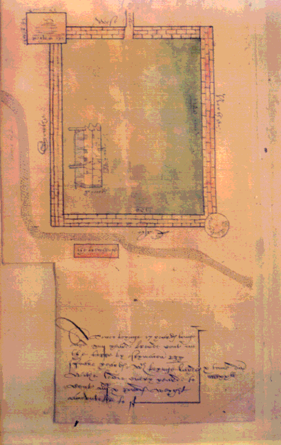
    [33] TCD 743 (G/ 2/ 16). This image is reproduced with the permission of The Board of Trinity College Dublin. The image may not be further reproduced from software - for reproduction, application must be made to the Keeper of Manuscripts, Trinity College Library Dublin, College Street, Dublin 2, Ireland (by post; or by fax +353-1-6082690/6719003, by email at mscripts@tcd.ie).[Back]

    [34] PRO MPF 277.[Back]

    [35] DNB.[Back]

    [36] Richard Bagwell, Ireland Under the Tudors (3 vols., London: Longman, Green, 1890) 3: 65.[Back]

    [37] PRO MPF 99.[Back]

    [38] Vewe 59.[Back]

    [39] FQ 2.9.13-15.[Back]

    [40] FQ 7.7.58. The real Irish castles of this period have been described as being "concerned with an architecture of towers and enclosing walls - the outcome of insecure existences lived between the conflicting demands of comfort, status, and safety." Niall McCullough and Valerie Mulvin, The Nature of Architecture in Ireland (Dublin: Gandon, 1987) 35.[Back]

    [41] "Mapping Mutability" 95.[Back]

    [42] The Production of Space trans. David Nicholson-Smith (Oxford: Blackwell, 1991) 38.[Back]

Works Cited

Responses to this piece intended for the Readers' Forum may be sent to the Editor at EMLS@UAlberta.ca.


© 1998-, R.G. Siemens (Editor, EMLS).

(RGS, JL, JWG, September, 1998)