-
In a proposal written for Elizabeth's Privy Council in
1577,[1] John Dee stressed the potential
power and supremacy of England, as well as her ability to achieve a great
and lasting empire.
No King, nor Kingdome, hath, by Nature and Humayn Industry
(to be used) any, more LAWFULL, and more Peaceable Means (made evident)
wherby, to become In wealth, far passing all other: In Strength, and Force,
INVINCIBLE: and in Honorable estimation, Triumphantly Famous, over all,
and above all other.[2]
Elizabethan geographers and cartographers, led by such important and influential
men as Dee, helped develop a set of attitudes and assumptions that encouraged
them to view the English as separate from and superior to the rest of the
world. Geography supplied the many students and politicians who studied
it with a belief in their own inherent superiority and their ability to
control the world they now understood.[3]
Indeed, the study of geography helped the English develop an imperial world-view
based on three underlying assumptions: a belief that the world could be
measured, named, and therefore controlled; a sense of the superiority of
the English over peoples and nations and thus the right of the English
nation to exploit other areas of the globe; and a self-definition that
gave these English students a sense of themselves and their nation.[4]
This message of superiority and the possibility of imperial expansion was
aided by the iconographic images present in many geographical works. Through
the constant repetition of such messages, students of geography began to
envisage a world open to the exploration and exploitation of the English.
-
Historians looking for the origins of the English and
British empires have long examined theoretical tracts emanating from such
moments as the Union of Crowns of 1603.[5]
These have yielded much valuable information, but do not give a wider sense
of the cultural interest in or proclivity towards these ideas. In order
to understand the underlying attitudes towards ideas of empire, we must
examine alternative discursive sites, for example, court masques, street
processions, and illustrated frontispieces.[6]
As historians such as Steven Shapin and Paula Findlen have shown, these
cultural analytic spaces often provide a clearer sense of the interplay
between intellectual ideas and their cultural and political applications.[7]
In this article, I will examine the imperial messages of popular geographical
texts, most particularly their illustrated frontispieces, in order to assess
these underlying imperial assumptions.[8]
While these frontispieces should not be seen as complete in themselves,
they demonstrate the widespread interest in and acceptance of these imperial
images.
-
The empire imagined in these geographical books and frontispieces,
however, did not have a single focus or direction. While the Spanish had
established a form of world dominion through conquest and the resulting
mineral wealth, the English were less sure of their method of expansion,
or the desired results. Thus the message of England's ability to venture
forth, for profit, power, and fame, as Dee had maintained, was troubled
by uncertainty as to just who should venture, what their goal should be
and what profit would accrue. The iconographic formation of the English
empire, while powerful for English readers of such geographical literature,
was thus unstable and perhaps contributed to the rather erratic development
of empire that was to follow.
-
The concept of empire can be traced back to the Roman
Empire. Anthony Pagden has identified three different usages of the term
empire, all with classical roots and all current in sixteenth-century Europe.[9]
An empire could in the first instance refer to a self-sufficient and omni-competent
state, the concept first articulated in England in Thomas Cromwell's famous
phrase, "this realm of England is an empire," in the Act in Restraint
of Appeals of 1533.[10] Secondly,
the empire could refer to the monarch who exercised imperium or
command over an area. Finally, and most significantly for sixteenth-century
Europe, empire referred to the extended control, usually of a Christian
monarch, over more than one geographical area.[11]
This last meaning, of course, encompassed the empire Spain claimed to have
created and thus the empire that most interested geographical writers in
late sixteenth- and early seventeenth-century England. And yet, the images
of empire developed by those most interested in promoting the creation
of an English empire were ambiguous in relation to this meaning. Many saw
Elizabeth or James as integral to any imperial adventure, but the underlying
message of these texts and images was much more haphazard and personal
than monarchical. Merchants and trade seemed just as if not more important
than conquest and glory. The creation of an English empire, while clearly
arguing for England's ability to achieve supremacy in the geopolitical
struggle, would not place Britannia on the ship of power and control. Rather
merchants and personal adventurers were to gain by this venture.[12]
As well, the tangible results of these early propaganda campaigns were
less than nothing, since all the expeditions potentially inspired by the
images and ideas I will discuss were unmitigated disasters.[13]
Perhaps this was partly due to the very ambiguity of these images, which
encouraged men in various governance and mercantile positions to think
of empire, but did not give them a clear sense of what this meant. This
troubled concept of empire would have far-reaching ramifications in the
creation of the actual empire of the next two centuries.[14]
I
-
The most overt iconographic example of imperial thinking
came from Dr. John Dee. Dee, a Master of Arts from Cambridge, was a mathematician,
astronomer, geographer, and on occasion necromancer. Though in recent years
Dee's name has become synonymous with occultist practices and Hermeticism,
in his own time he was much better known as a learned and practical geographer.[15]
His interest in astronomy, astrology, and geography was established while
a student, and it was this initial spark that sent him on to Louvain to
study with those great mathematicians and geographers, Gemma Frisius and
Gerard Mercator, among others.[16]
He later returned to England, where he set himself up as an astrologer
and geographical advisor, becoming astrologer to Elizabeth (in which capacity
he advised her on hydrographical and geographical matters) and advising
the Muscovy Company, Humphrey Gilbert, and numerous other practical geographers.[17]
He was equally an overt promoter of English imperialism, especially although
not exclusively in General and Rare Memorials Pertayning to the Perfect
Arte of Navigation (1577).[18]
Responding to a series of serious threats to maritime security, Dee proposed
that Elizabeth establish a Royal Navy to protect England from pirates,
the English fishery from incursions, and to aid in the establishment of
a British maritime empire. Dee directed to the politically powerful men
surrounding Elizabeth an overt message of imperialism and of the necessity
of using scholarly knowledge for the good of the common weal. In less overt
terms, these were the lessons to be gained from a variety of books of geography
and from the study of geography itself.[19]
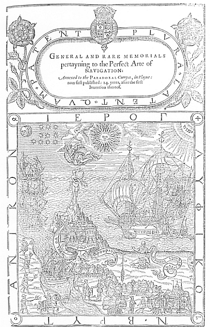
The illustrated title page to Dee's book provides a visual representation
of this message of power and hegemonic potential, while at the same time
warning the English of the danger of ignoring this opportunity. (See Figure
1.) While some title-pages may reflect the printer's aesthetic
or practical concerns (as we shall see, some title-pages were used for
a variety of books), this title-page, present in both manuscript and printed
copies, bears Dee's unmistakable imprint.[20]
In this engraving, Elizabeth commands the ship of state, labelled Europa.
The Royal coat of arms on the rudder indicates Dee's prophecy (and present
claim) of England's supremacy and leadership of Europe. Elizabeth is receiving
her advisors, but she looks toward naked lady Occasion (or Fortuna), standing
on the fortress to the left. Elizabeth holds out her right hand to grasp
Fortune's forelock and the laurel wreath she holds -- undoubtedly by founding
her great Royal Navy. Britannia, kneeling on the shore, desires Elizabeth
to seize her opportunity with a "fully-equipped expeditionary force," as
her scroll states.[21] This navy
is to be much more than a coast guard patrolling for pirates; rather it
will begin the divinely sanctioned creation of an English Empire. God,
Elizabeth, and St. Michael on the right fight back the darkness on the
left and the naval force will soon capture the foreign ships at sea. There
is also a more ominous warning here, since the skull on the right acts
as a memento mori and may be related to the ear of wheat, a Hermetic
symbol for man, here somewhat inauspiciously reversed. In other words,
if the readers ignore Dee's perspicacious proposal, England's end may be
less than felicitous. Indeed, there are a number of hints that magic may
play a part in England's greatness, from the Latin motto surrounding the
title, "Plvra: Latent: quam: Patent" (More things are concealed than are
revealed),[22] to the Greek symbols
in the four corners, which add up to Dee's Monas Hieroglyphica.[23]
It is tempting to see a strong parallel between the discovery of the philosopher's
stone and the creation of England as an imperial power. It is a mistake,
however, to take this too far, since this text was intended for a select
group of Elizabeth's advisors and some vague claim to mystical transformation
would not have been particularly appropriate.[24]
-
If there was any doubt of the imperial message on this
title-page, Dee lays it out in the text.
Why should not we HOPE, that, RES-PVBL. BRYTANICA, on her knees,
very Humbly, and ernestly Soliciting the most Excellent Royall Maiesty,
of our ELIZABETH (Sitting at the HELM of this Imperiall Monarchy: or, rather,
at the Helm of the IMPERIALL SHIP, of the most parte of Christendome: if
so, it be her Graces Pleasure) shall obteyn, (or Perfect Policie, may perswade
her Highnes,) that, which is the Pyth, or Intent of RES-PVBL. BRYTANICA,
Her Supplication? Which is, That, [a fully equipped expeditionary force],
may helpe vs, not onley, to [a citadel of safety, such as Fortune stands
on]: But make vs, also, Partakers of Publik Commodities Innumerable, and
(as yet) Incredible.
Thus Elizabeth, already commanding the imperial ship as a leader of Christendom,
can employ this new Navy Royall both to defend the autonomy of England
and, more importantly, to achieve wealth, power, and hegemony. Elizabeth's
location in this picture is extremely telling. Dee first places her in
charge of the ship as an "Imperiall Monarchy," an important position implying
dominion over more than one country, both legislatively and spiritually.[25]
He then corrects this to claim her greater place at the helm "of the most
parte of Christendome." This implies an eschatological role as the Protestant
saviour of Europeans and the newly discovered peoples alike.[26]
Britannia herself, of course, kneels in a much subsidiary position, clearly
beholden to this monarch, rather than in any way defining her. It is Elizabeth,
not Britannia, who will make possible the safety of the country, and even
more important, in the perhaps unconscious echo of the communion prayer
of consecration, it is Elizabeth who will allow the development of new
mercantile endeavours. Dee goes on to place divine sanction on these expansionist
and mercantilist ambitions by continuing:
Vnto which, the HEAVENLY KING, for these many yeres last past,
hath, by MANIFEST OCCASION, most Graciously, not only inuited vs: but also,
hath made, EVEN NOW, the Way and Means, most euident, easie, and Compendious:
In-asmuch as, (besides all our own sufficient Furniture, Hability, Industry,
Skill, and Courage) our Freends are become strong: and our Enemies, sufficiently
weake, and nothing Royally furnished, or of Hability, for Open Violence
Vsing: Though their accustomed Confidence, in Treason, Trechery, and Disloyall
Dealings, be very great. Wherein, we beseche our HEAVENLY PROTECTOR, with
his GOOD ANGELL to Garde vs, with SHIELD AND SWORD, now, and euer. Amen.[27]
According to Dee, God takes up the cause of the expansionist English, through
the intervention of his sword-wielding angel, Michael. By weakening its
enemies and strengthening its friends, God has shown England that it is
now time to act.
-
Dee's book provided a strong pronouncement of the imperial
ideology present in geographical discourse, both in the imagery of the
title-page and in the message of the text. The audience for General
and Rare Memorials was undoubtedly small, but included some of the
most influential privy councilors of the day.[28]
Although the navy was never established, several of Elizabeth's key advisors
appreciated and shared this imperial vision for England. Dee's picture
of empire was a complex one, with Britannia subservient to Elizabeth's
dominion, and Elizabeth herself supplying the wherewithal for private profit
as well as national glory. For all its peculiarities, however, Dee's work
shared with many other geographical treatises an overt desire for an imperial
future for England.
-
These imperial messages, as well as geographical information
about the wider world more generally, were read by a large group of men,
some the principal politicians and investors of early modern England, and
others destined for lesser political, judicial or church careers. This
study of geography, often at university, provided them with a sense of
English superiority and potential hegemony, as well as with examples of
the heroic feats of those champions of English expansion who had gone before.[29]
The vision of geography informed these men that England stood poised on
the brink of a great imperial adventure, in which they could and should
participate.
II
-
Many of the geography books popular with university scholars
in the period after Dee's book was published contained this message of
English power and potential. The images of empire they conveyed, like Dee's,
were multi-faceted, and many asked similar questions as to the real source
of power, and the recipients of wealth. At the same time, they stressed
the potential for England to achieve a greater empire, both materially
and spiritually, than Spain or any other rival European power. Richard
Hakluyt, for example, in a widely-read compilation of travel narratives
and geographical descriptions published in 1598-1600, declared through
the narrative of Richard Willes, that the English were most suited to explore
and control the eastern trade.
The rude Indian Canoa halleth those seas, the Portingals, the
Saracenes, and Moores travaile continually up and downe that reach from
Japan to China, from China to Malacca, from Malacca to the Moluccaes: and
shall an Englishman, better appointed than any of them all (that I say
no more of our Navie) feare to saile in that Ocean: What seas at all doe
want piracie: What Navigation is there voyde of perill?[30]
Hakluyt's massive collection proved a very important source for English
pride and imperial hope. Hakluyt perused historical sources to find long-forgotten
English voyages in order to argue that the English had the right to foreign
lands through first discovery.[31]
He also included many modern voyages by the English (and others) and in
this contemporary reportage he used the words of people who had been there,
a style of reporting that lent great verisimilitude to his stories and
allowed his readers to see the real passion and poetry, as well as hard-nosed
business sense, of England's travellers.[32]
His book let the English mariner or merchant develop a self-consciousness
of his role in the world and so Hakluyt's book encouraged a view of a very
personal and trade-oriented empire. There was no doubt that this would
be an empire for the glory of Queen and country, but exactly who would
have dominion was rather less clear.
-
John Wolfe also supplied an imperial message when he
published a translated version of Jan Huygen van Linschoten's Discours
of Voyages in 1598. Linschoten, a Dutch adventurer, had written a book
describing Dutch and Portuguese voyages to distant locations, including
a description of the Congo by a Portuguese explorer and an analysis of
the Spanish tax system, as well as his own travels to the East Indies.
Wolfe had Linschoten's book translated by W. P[hillips], at the behest
of Richard Hakluyt.[33] It was one
of a number of geographical descriptions published by Wolfe, sometimes
in Italian and often translated into English at Hakluyt's suggestion.[34]
Little is known of Wolfe's motivations in publishing these books (aside
from a shrewd assessment of the market), although when placed with his
early struggles against the Stationers' Company over their monopoly on
printing lucrative texts,[35] one
is left with an impression of entrepreneurial savvy. By the time he published
Linschoten's voyages, he was a successful senior member of the Stationers'
Company and had achieved the prestigious title of Printer for the City
of London, as the Linschoten title-page proclaimed. Near the end of his
successful career, Wolfe exhorted the English in the introduction of the
translation to take their rightful place as an ocean-going, imperial nation,
both for the riches such action would bring to England and for the civility
they would return to inferior parts of the world. Although Linschoten's
Discours
ostensibly talks of the imperial growth of other nations, Wolfe here reconfigures
the book as a story to construct an English imperial identity.
I doo not doubt, but yet I doo most hartely pray and wish,
that this poore Translation may worke in our English Nation a further desire
and increase of Honour over all Countreys of the World, and as it hath
hitherto mightily advanced the Credite of the Realme by defending the same
with our Wodden Walles . . . So it would employ the same in forraine partes,
aswell for the dispersing and planting true Religion and Civill Conversation
therein: as also for the further benefite and commodity of this Land by
exportation of such thinges wherein we doe abound, and importation of those
Necessities whereof we stand in Neede: as Hercules did, when hee fetched
away the Golden Apples out of the Garden of the Hesperides; and Jason,
when with his lustie troupe of couragious Argonautes hee atchieved the
Golden Fleece in Colchos.[36]
-
Proven by its successful defeat of the Armada, employing
its famous "wooden walls," the English nation has here become like Hercules,
the semi-divine, or Jason, with his great sea-faring abilities and divinely
ordained success. These two mythic figures do seem to have been recreated
as nascent mercantilists, arguing for the classical precedents of early
modern plunder. Wolfe sees such unequal exchanges (Hercules and Jason,
after all, did not pay for their prizes, except by personal sacrifice and
hardship) as at least on a par with the need to bring true religion and
civil conversation to the natives of foreign locales. Indeed, the civility
and Protestantism of the English equip them particularly well to pursue
the import and export trade for the further "benefite and commodity" of
England itself. This is an imperial design, arguing for England's inherent
superiority and ability to achieve dominion over other parts of the world,
with a clear primacy of trade and commerce over conquest.
-
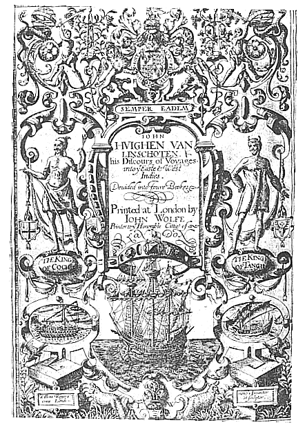
Indeed, the Englished Linschoten provides another important
illustration of English imperialism, while expropriating the valorous deeds
of another nation. Linschoten's book, in Wolfe's edition, contains the
tales of Dutch and Portuguese adventure and profit, as well as evidence
of Spanish wealth and power at home. Yet, on examining the illustrated
title page, a tale of English supremacy is laid before the reader.
(See Figure 2.)
At the top, the royal coat of arms with the garter motto and Elizabeth's
motto, "Semper Eadem," anchors the book firmly in an English, courtly
context. The translation was dedicated to Sir Julius Caesar, Judge of the
High Court of Admiralty and Master of Requests to the queen, thus directed
as Dee's work had been to the powerful patronage circles.[37]
Below the title, a large and very impressive carrack rides at anchor. The
prominent flag jutting into the title space indicates English ownership.[38]
The coat of arms on the left belongs to the City of London, announcing
that this book was directed to merchants as well as courtiers. This also
reminds the viewer of Wolfe's privileged position as the Printer of London,
also mentioned in the text. Thus, although the book itself described foreign
exploits and enterprises, the message of the illustrated title page and
introduction show that even these were to be used to the glory of England
and to aid in the creation of an English empire. Just as Hakluyt used tales
of other nations' discoveries to spur on English adventuring and commerce,
Wolfe too hoped that exposure to the exploration of new parts of the world
would encourage the English to venture forth for glory and profit.[39]
While England would certainly benefit from these potential imperial ventures,
the glory and profit had personal implications as well.
-
Christopher Saxton's illustrated frontispiece, from his
1579 atlas, also contains an overt message of English power and the utility
of the geographical sciences in achieving such power. Saxton's atlas was
funded by government patronage in the guise of Sir Thomas Seckford, Master
of Requests, and was based principally on Saxton's own surveying.[40]
This atlas marks an important development in government interest in a visual
representation of the country, providing as it does the first clear image
of the entire span of England, county by county. In Saxton's frontispiece,
Elizabeth sits enthroned in the centre of the image, patron and ruler over
the men on either side of her canopy.[41]
On the right stands geography with compass and globe; on the left is astronomy
with his armillary sphere. The usual female personifications of these disciplines
has been replaced by men in middle eastern garb, perhaps alluding to the
two works of Ptolemy. In the cartouche above Elizabeth's head, Righteousness
and Peace, both female, embrace under Elizabeth's rule. Below, the two
aspects of map-making, geometric and panoramic, seem to set their sights
on England and Elizabeth's patronage. Since Elizabeth's support was of
utmost importance in the funding of this atlas, it makes sense that Saxton
would acknowledge this on the title page. Indeed, Saxton had received Grigston
Manor in Suffolk from Elizabeth in 1574, in recognition of his work and
expenses.[42] The royal coat-of-arms
crowned above confirms the importance to the queen and her government of
mapping the English counties. Elizabeth reigned over all that could be
measured and such mathematical control would enable England to triumph
over its enemies.
-
As the maps of the atlas indicate, Saxton's recording
of musters, lords lieutenant and places of fortification were matters of
extreme importance to the Privy Council, concerned as it was with the coming
war with Spain. Lord Burghley especially had been extremely keen on Saxton's
mapping of the entire country, obtaining each map as it was completed and
creating his own atlas for administrative use.[43]
The image of empire created by this title page, and by the atlas it introduced,
was that of a self-sufficient and omni-competent state, ruled over by the
dominion of a wise monarch. While this was problematized by the increasing
separation of crown and county found on the later maps of the atlas,[44]
Saxton's work contributed to a growing identification with England and
its sense of self-sufficiency.
III
-
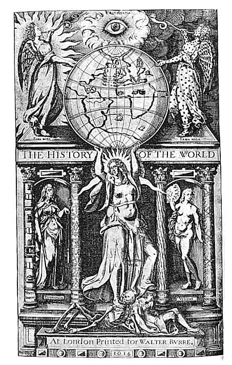
While Saxton's title page suggests a relatively stable
view of England as an imperial nation, Sir Walter Ralegh's message in The
History of the World (1614) is rather more complex. (See Figure
3.) The war with Spain is apparent as an important component
in English self-definition in Ralegh's self-designed frontispiece.[45]
That war had been a defining moment for Ralegh himself, as well as the
source of much mythologizing for English imperialists. So it is perhaps
no surprise that the map dominating Ralegh's frontispiece would depict
a vigorous battle in the Atlantic between Spanish and English forces --
except for the fact that Ralegh's book deals with the history of the world
to the second century BC.[46] The
map, a truncated version of Ortelius' 1570 world map, has been oriented
to place England and Ireland in the centre. Ralegh's ship seems once more
venturing forth in search of El Dorado in the South Atlantic and both it
and England are under the watchful eye of providence above. This masonic
symbol suggests, as with Dee, a connection between the underlying magic
of the world and the geographical control of that world. History herself
holds the earth up to God's gaze, so that the actions thereon can be judged
to have good or evil fame. With God watching over England and English deeds,
how can her future be other than magnificent?
-
Ralegh wrote The History of the World during an
eleven-year imprisonment in the Tower of London. Although it deals with
the history of the world from creation to just before the birth of Christ,
the parallels with modern concerns were real and explicitly drawn.[47]
Indeed, James' reason for suppressing its publication lay in the fact that
Ralegh was "too saucy in censuring princes."[48]
This book was written as part of a campaign by Ralegh to interest Henry,
Prince of Wales, in imperial adventures in general and in supporting Ralegh's
conquistadorial bid to find El Dorado in particular.[49]
Unfortunately for Ralegh, Henry died before the book was completed, accounting
for its rather abrupt ending. For Ralegh, the hope of a glorious English
or even British empire to rival Spain died with Henry, and although he
returned once more to Guiana, it was to face ignominy and execution on
his return.[50] Thus, the message
of his frontispiece is a curious mixture of bravado and fatalism. History,
stamping out death and oblivion, will reveal to God and the English Ralegh's
great vision of empire, first glimpsed through the victory of the "Wodden
Walles" of the Armada (echoing Wolfe's earlier claim). As Ben Jonson explained
in the accompanying poem:
From Death and darke Oblivion (neere the same)
The Mistress of Mans life, grave Historie,
Raising the World to good, or Evill fame,
Doth vindicate it to Aeternitie.[51]
Magistra Vitae, with her orb above her, bears more than a passing
resemblance to an older iconographic image of Lady World, suggesting the
vanity of all earthly ambition.[52]
Ralegh, more than any other writer or explorer, represented the empire
of conquest rather than commerce or settlement, although the predetermined
failure of such a course must colour any viewing of this triumphal frontispiece,
then or now.
IV
-
Were these imperial messages, with all their multiple
meanings, read by men intended for public office? Elsewhere I have argued
that there is much evidence that they were.[53]
Many students owned and read these books and many others with underlying
imperial themes; a majority of these students went on to public careers
of one type or another. This attention to geographical information and
its message can be illustrated graphically as well as through content by
an examination of a commonplace book owned by Sir Julius Caesar. Caesar
was an English-born son of the Italian doctor, Caesare Adelmare, who was
physician to Elizabeth and Mary. After receiving an MA. at Oxford, Sir
Julius became a student at the Inner Temple and received his LL.D. from
Paris in 1581. He became Judge of the Admiralty and Master of Chancery
under Elizabeth. With James' accession, Caesar became Chancellor of the
Exchequer and, in 1614, Master of the Rolls, both positions being held
until his death in 1636.[54] As
we saw, John Wolfe dedicated his translation of Linschoten to Caesar, believing
him to be interested in geography and exploration. Wolfe claimed that Caesar,
as the Judge of the Admiralty, was in a position to judge how important
the information in Linschoten's book was to the promotion of the English
Nation in imperial ventures.[55]
Here then is one of the "new men" who achieved power in early modern English
governance, aided by a university education. If images of geographical
imperialism were absorbed by him, they had the potential to be translated
into action.
-
Caesar began compiling a commonplace book at Oxford in
the 1570s and continued to add to it throughout his life. The book he used
was a printed commonplace book: the Pandecte Locorum Communium.
This book, published in 1572 with an introduction by John Foxe, contains
a title page with edifying verse, running heads throughout the book, and
an index at the end, while the majority of the book is left blank for the
use of the owner.[56] Given John
Foxe's hand in the production of this volume, it is no surprise to see
the preponderance of religious and moral topics implied by the various
headings. What is more interesting for our purpose is the large number
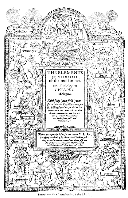
of geographical headings, especially when combined with the illustrated
title page, which suggests that the quadrivium generally, and geography
particularly, were of prime importance to the student compiling his commonplace
book. (See Figure
4.) This title page was first used by publisher John Day to illustrate
William Cuningham's Cosmographical Glass (1559) and Dee and Billingsley's
1570 English translation of Euclid, so had wider currency than simply
this commonplace book.[57] It was
relatively common for printers to reuse title pages, since they were expensive
to produce. As Day published a lot of mathematical and scientific material,
such a title page was very useful. It is striking that John Day chose to
use such a mathematically and geographically-oriented title page for this
commonplace book, emphasizing the importance of these areas for all students
of the commonplace. In the bottom half of the page sit the female personifications
of the four mathematical arts: Geometria and Arithmetica on the left and
Astronomia and Musica on the right. Each holds the instrument traditional
to her art. In the absence of their sisters of the trivium, this
certainly suggests a strong emphasis on those studies more closely identified
with mathematical studies of the natural world. Mercury as the God of learning
presides over their collaboration. Even more striking is the top of the
page. We might expect the great classical authors, whose works the attending
students would surely be recording. We are not disappointed -- except that
these are all geographers, a fact made more evident by the instruments
they hold. At the top, on either side of a terrestrial globe, centred on
the Old World, stand Ptolemy and Marinus, considered to have been his predecessor.
Below them are Aratus and Hipparchus on the left and Strabo and Polibius
on the right. Strabo is even engaged in drawing a map, an interesting endeavour
for the father of descriptive geography. Even more interesting, it is a
map of England. Look at the stars, Ptolemy seems to say, but with Strabo
you know where you are. This message of geographical emplacement, at the
very start of an important published commonplace book, demonstrates the
importance of geographical thought and study to serious students.
-
Caesar appears to have kept this commonplace book throughout
his life; his first entry was made while at Magdalen Hall, Oxford, in 1577
at the age of nineteen, and the last entry is dated 1636, shortly before
his death.[58] In it he recorded
a lifetime of citations, quotations, and ideas. He seems to have had relatively
little to say on the pages devoted to theology and mathematics, but the
sections of the notebook devoted to geography and navigation are closely
filled. Indeed, he added several manuscript pages with the running heads
"Cosmographia, Geographia."[59]
He cited all the important geographical authors, including Ptolemy, Mercator,
Strabo, and Pliny. He discussed navigation in terms of the care and design
of ships, and included chorography in such entries as "The Singularities
of England."[60] His descriptions
of other countries were usually drawn from or referred to published authorities,
although sometimes he recorded his own observations.
I was ownce in Italie my selfe: but I thanke god, my abode
there was but 9. daies; and yet I sawe in that little time in the citie
of Venice, more libertie to sinne, than ever I heard tell of in our noble
citie of London in 9 yeare. I sawe, it was there as free to sinne, not
onely without all punishment, but also without anie man's marking, as it
is free in the citie of London, to chouse without all blame, whether a
man hast to weare shoe or pantoche.[61]
Caesar's commonplaces, added to through out his life, show a man of substance
interested in geographical issues. He read widely from the books we have
been examining and saw such information as important. This information
helped him develop a notion of England as a separate and self-sufficient
country (as his note on Italy suggests) and to begin to think of ways to
increase the possibility of England's foray into outward imperialism.
V
-
From the late seventeenth century on, the English began
to realize the potential of imperial thinking. The first step in such empire
building was their subjugation of the Irish and union with Scotland, resulting
in the creation of Britain by 1707. This was followed by a rapid expansion
in influence and control over large segments of the world; the British
empire was a reality by the end of the eighteenth century. But in order
to conquer the world in this way, the English first needed a vision of
themselves as an imperial nation. This self-image as an independent and
omni-competent country, as well as one with the potential to control other
countries and regions of the world, had to precede the acquisition of an
empire and so the English needed an imperial ideology before they could
begin to construct an empire in deed. The creation of this ideology of
empire was aided by the study of geography. The images I have examined
in this article contributed to this sense of superiority and separateness,
although they were not unanimous in the message they communicated. While
all were agreed that England (or the English) had the right to take their
place as an imperial nation, they were much less united on the means to
that goal, or just what the final imperial country would look like. With
the exception of Ralegh, for whom conquest was less for personal gain than
for the glory of his monarch, these geographical authors sought success
in trade, in some settlement and in the transmission of "true Religion
and Civil Conversation."[62] Britannia,
as some coherent entity, did not rule even the iconographic waves, though
the race for exploitation and hegemony had begun.
Notes
1. William H. Sherman establishes
the audience for this book in John Dee: The Politics of Reading and
Writing in the English Renaissance (Amherst: U of Massachusetts P,
1995) 149-152.
[Back]
2. John Dee, General and
Rare Memorials pertayning to the Perfect Arte of Navigation (London,
1577) 63.[Back]
3. See Lesley B. Cormack, "'Good Fences
make Good Neighbors': Geography in Early Modern England," Isis 82
(1991): 639-661, for a definition of geography in this period. I here follow
David Livingstone's insistence on the "situated messiness" of the geographical
tradition, The Geographical Tradition. Episodes in the History of a
Contested Enterprise (Oxford: Blackwell, 1992). For some interesting
Scottish comparisons, see Charles Withers, "Geography, Royalty and Empire:
Scotland and the Making of Great Britain, 1603-1661,"
Scottish Geographical
Magazine 113 (1997): 22-32; "Geography, Science and National Identity
in Early Modern Britain: The Case of Scotland and the Work of Sir Robert
Sibbald (1641-1722)," Annals of Science 53 (1996): 29-73; and "How
Scotland Came to Know Itself: Geography, National Identity and the Making
of a Nation, 1680-1790," Journal of Historical Geography 21 (1995):
371-387. [Back]
4. Lesley B. Cormack, Charting
an Empire. Geography at the English Universities 1580-1620 (Chicago:
U of Chicago P, 1997). [Back]
5. For example, Brian Levack, The
Formation of the British State: England, Scotland and the Union 1603-1707
(Oxford: Clarendon, 1987); Jenny Wormald, "The Creation of Britain: Multiple
Kingdoms or Core and Colonies," Transactions of the Royal Historical
Society 6 (1992): 175-194; and J. Robertson, "Empire and Union: Two
Concepts of the Early Modern European Political Order," in J. Robertson,
ed., A Union for Empire: Political Thought and the British Union of
1707 (Cambridge: Cambridge UP, 1995) 3-36. [Back]
6. Frances Yates, Astraea: The
Imperial Theme in the Sixteenth Century (London: Routledge & Kegan
Paul, 1975); Graham Parry, The Golden Age Restor'd: The Culture of the
Stuart Court 1603-1642 (Manchester: Manchester UP, 1971); Roy Strong,
Art
and Power: Renaissance Festivals 1450-1650 (Woodbridge: Boydell, 1984);
and Withers, "Geography, Royalty and Empire." [Back]
7. Steven Shapin, A Social History
of Truth: Civility and Science in Seventeenth-Century England (Chicago:
U of Chicago P, 1994); Paula Findlen, Possessing Nature: Museums, Collecting,
and Scientific Culture in Early Modern Italy (California: U of California
P, 1994). [Back]
8. These is a wide literature in the
emblematic analysis of frontispieces, e.g. Peter M. Daly, Literature
in the Light of the Emblem. Structural Parallels between the emblem and
Literature in the Sixteenth and Seventeenth Centuries (Toronto, 1979).
I have been most influenced by William B. Ashworth, Jr., especially "Natural
History and the Emblematic World View" in Reappraisals of the Scientific
Revolution, David Lindberg and Robert Westman, eds. (Cambridge, 1990),
pp.303-332. See also Michel Foucault, The Order of Things (New York,
1970). Foucault's categorization of the sixteenth century as the "age of
similitude" is very useful here. [Back]
9. Anthony Pagden, Lords of All
the World. Ideologies of Empire in Spain, Britain and France. c.1500-c.1800
(New Haven: Yale UP, 1995) pp. 11-28. [Back]
10. Lesley B. Cormack, "The Fashioning
of an Empire: Geography and the State in Elizabethan England," in
Geography
and Empire, Anne Godlewska and Neil Smith, eds. (Oxford: Blackwell,
1994) 16-17. [Back]
11. Pagden, Lords of All the World
14. [Back]
12. Richard Helgerson, Forms of
Nationhood: The Elizabethan Writing of England (Chicago: U of Chicago
P, 1992) 171-181, discusses Hakluyt's tension between mercantile practicality
and royal nationalism. [Back]
13. Jeffrey Knapp, An Empire Nowhere.
England, America, and Literature from Utopia to The Tempest
(Berkeley: U of California P, 1992), claims that by stressing England's
otherworldliness and trifling with conquest, English writers idealized
the colonial failures of this period. [Back]
14. Pagden argues that the lessons
learned by Spain, England and France during what he calls the first imperial
period changed the way that particularly England, France and the Netherlands
dealt with the rather different eastern imperial expansion of the late
eighteenth and early nineteenth centuries. 1-10. [Back]
15. Peter French, John Dee: The
World of an Elizabethan Magus (London: Routledge & Kegan Paul,
1972); Richard Deacon, John Dee: Scientist, Geographer, Astrologer and
Secret Agent to Elizabeth I (London: Muller, 1996); and Frances Yates,
especially
Theatre of the World (London: Routledge & Kegan Paul,
1969), have done much to encourage this tendency to see Dee as an Elizabethan
"magus." While it is true that Dee was very interested in alchemy, numerology,
astrology, and, in the end, crystal ball gazing, most of these activities
were legitimate sixteenth-century pursuits and the focus on this has obscured
his important geographical work. Even historians such as Sir Roy Strong,
Henry,
Prince of Wales and England's Lost Renaissance (London: Thames and
Hudson, 1986), are not immune from this tendency, claiming Prince Henry's
interest in Dee was neo-Platonic rather than exploring the more obvious
geographical link. Clulee provides a much more balanced view of Dee's work,
arguing in John Dee's Natural Philosophy: Between Science and Religion
(London: Routledge, 1988) that as Dee grew more interested in natural magic,
he became less concerned with natural philosophy. Sherman,
John Dee,
has begun to set the record straight on Dee, showing his close interconnection
with court and government, and establishing the primacy of his geographical
work. [Back]
16. Mark Curtis, Oxford and Cambridge
in Transition 1558-1642 (Oxford: Clarendon, 1959) 242; French, John
Dee 28. [Back]
17. John Dee, The Private Diary
of Dr. John Dee, and the Catalogue of his Library Manuscripts, J.O.
Halliwell, ed. (London: Camden Society, 1842; New York: AMS, 1968), records
many instances of these men coming to consult with Dee before undertaking
hazardous voyages.
[Back]
18. Sherman, John Dee, chap.
7, includes a close reading of General and Rare Memorials, as well
as Of Famous and Rich Discoveries (ms. 1577) and Brytanici Imperii
Limites (1576-78). In so doing, he makes explicit the link between
Dee, imperialism, and the Privy Council. [Back]
19. Cormack, Charting an Empire.
[Back]
20. Bodleian Ashmole MS 1789, ff.
116-17b, provides the manuscript version in Dee's hand. This image, together
with the others in this article, is reproduced by kind permission of the
British Library. [Back]
21. For standard interpretations
of this illustrated title page, see Joseph Ames, Typographical Antiquities,
Vol. 1 (London, 1810) 660-662; Margery Corbett and Ronald Lightbown, The
Comely Frontispiece. The Emblematic Title-Page in England 1550-1660
(London: Routledge & Kegan Paul, 1979) 49-58. French, John Dee
183-185, provides a Hermetic twist to this image. [Back]
22. Corbett and Lightbown, Comely
Frontispiece 49. [Back]
23. John Dee, Monas Hieroglyphica
(Antwerp, 1564). David Livingstone, "Science, Magic and Religion: A Contextual
Reassessment of Geography in the Sixteenth and Seventeenth Centuries,"
History
of Science 26 (1988): 269-294, sees a direct relationship between geography
and magic, especially in Dee's work. I disagree with the proposition that
magic was an integral ingredient in sixteenth-century geography. In fact,
even John Dee seems to have kept the two relatively separate in his dealings
with geographers and navigators. Still, the symbolism of this title-page
argues for a closer relationship and the use of magic for the aggrandisement
of the state. [Back]
24. Sherman, John Dee 149-150.
[Back]
25. Pagden notes that the Spanish
were the first to speak of the Spanish Monarchy rather than Kingdom, to
show the king of Spain as an emperor through heredity. Lords of All
the World 43. [Back]
26. Again, Pagden demonstrates that
the Spanish placed great store in the fact that the Pope had appointed
them to convert the natives, a position heavily criticized by English commentators,
as well as some Spaniards. Lords of All the World, pp. 29-33, 44-62.
See also Pagden, The Fall of Natural Man (Cambridge: Cambridge UP,
1982). [Back]
27. Dee, General and Rare Memorials
53. [Back]
28. Sherman, John Dee 166-170.
[Back]
29. Cormack, Charting an Empire.
[Back]
30. Richard Willes, "Certain other
reasons, or arguments to prove a passage by the Northwest, learnedly written
by Mr. Richard Willes Gentleman," in Richard Hakluyt, Principal Navigations,
Voyages, Traffiques and Discoveries of the English Nation (London,
1598-1600) 3.28. [Back]
31. Pagden sees this as an important
counter-argument to Spain's claim to empire through conquest. Lords
of All the World 880-81. [Back]
32. Hakluyt, Principal Navigations
1. sigs. *4a, *5a. [Back]
33. Introduction to Jan Huygen van
Linschoten,
Discours of Voyages (London, 1598) sig. A1a. [Back]
34. Clifford Chalmers Huffman, Elizabethan
Impressions. John Wolfe and his Press (New York: AMS, 1988) 36-41.
Most influential was Wolfe's English edition of The Historie of the
Great and Mightie Kingdome of China, by Mendoza (London, 1588), which
remained the standard account of China for English readers for a generation.
[Back]
35. Huffman, Elizabethan Impressions
129. [Back]
36. Introduction to Linschoten, Discours
sig. A4a. [Back]
37. Introduction to Linschoten, Discours
sig. A1a. Thanks are due to the British Library for permission to reproduce
the illustration. [Back]
38. Corbett and Lightbown, in The
Comely Frontispiece , 81-9, describe this title page. They claim the
ship is Portuguese, but have clearly missed the significance of the flag.
[Back]
39. Huffman, Elizabethan Impressions,
41, discusses Wolfe's explicit statement of this desire in many of his
Italian travel books and in the Mendoza translation.[Back]
40. Sarah Tyacke and John Huddy,
Christopher
Saxton and Tudor Map-making (London: British Library, 1980) 25. I.M.
Evans and H. Lawrence, Christopher Saxton: Elizabethan Map-maker
(Wakefield: Wakefield Historical Publications, 1979) 9, 66 ff. P.D.A. Harvey,
Maps
in Tudor England (Chicago: U of Chicago P, 1993), also discusses Saxton
and sees the publication of his Atlas as a cause of the map-consciousness
of the later Elizabethan years. 84. Instead, I see both caused by the shared
education in geography these gentlemen received as they increasingly attended
Oxford and Cambridge. A reproduction of this illustration was not available
for use in this article. [Back]
41. William Ravenhill, p. 15, introduction
of Christopher Saxton's Sixteenth-Century Maps (Chatsworth Library,
1992). [Back]
42. Tyacke and Huddy,Christopher
Saxton and Tudor Map-making 6.[Back]
43. Evans and Lawrence, Christopher
Saxton 6. [Back]
44. Richard Helgerson, "The Land
Speaks: Cartography, Chorography and Subversion in Renaissance England,"
Representations
16 (1986): 51-85. [Back]
45. C.A. Patrides, intro. to Sir
Walter Ralegh,
The History of the World (London: Macmillan, 1971)
xv. The book was initially suppressed and on its release later in 1614,
the title page had been removed. Thus, the image presented here, with no
author's name, is a frontispiece, rather than a title page proper. [Back]
46. Sir Walter Ralegh, The History
of the World (London, 1614). For a discussion of the frontispiece,
see Corbett and Lightbown, The Comely Frontispiece 134. [Back]
47. Ralegh, "Preface," sigs. A1a-E4b.
Stephen Coote, A Play of Passion: The Life of Sir Walter Raleigh
(London: Macmillan, 1993) 340. [Back]
48. Quoted by Coote, A Play of
Passion 341. [Back]
49. Coote, A Play of Passion
341-343.
[Back]
50. For an interesting discussion
of Ralegh's earlier failure in Guiana, see Knapp; as well as Charles Nicholl,
The
Creature in the Map: A Journey to El Dorado (London: Cape, 1995), who
discusses the potential Rosicrucian connections, especially with the naming
of the Red Cross River, 309-318. [Back]
51. Ben Jonson, "The Minde of the
Front,"
History of the World (1614), facing frontispiece. [Back]
52. Richard Helgerson suggested this
image in his paper, "The Folly of Maps and Modernity," at the conference
Paper Landscapes. Maps, Texts and the Construction of Space 1500-1700,
London, July 1997. [Back]
53. Cormack, Charting an Empire,
examines the geography books owned by students at Oxford and Cambridge,
as well as following the public careers of those students with geographical
interests.
[Back]
54. See DNB, vol. 8. 204-207;
and L.M. Hill, Bench and Bureaucracy. The Public Career of Sir Julius
Caesar, 1580-1636 (Cambridge: James Clarke, 1988). [Back]
55. John Wolfe, "Dedication," Discours
of Voyages sig. A1a. [Back]
56. Sir Julius Caesar's Commonplace
Book. B. L. Add. MS 6038. This is described for some political and religious
detail by Hill, Bench and Bureaucracy. Although Ann Moss, "Printed
Commonplace Books in the Renaissance," Acta Conventus Neo-Latini Torontonensis,
eds. A. Dalzell, C. Fantazzi, and R. Schoeck, 509-518 (Binghamton: Medieval
& Renaissance Texts & Studies, 1991) addresses the issue of commonplace
books printed in their entirety (with no blank space for personal additions),
she does not mention this form, with printed running heads and most of
the book left blank. [Back]
57. S.K. Heninger, Jr., The Cosmographical
Glass. Renaissance Diagrams of the Universe (San Marino: Huntington
Library, 1977), was the first to describe in detail the iconography of
this title-page, 1-3. [Back]
58. L.M. Hill, Bench and Bureaucracy,
6. [Back]
59. B.L. Add. MS 6038, f. 348a [Back]
60. B.L. Add. MS 6038, ff. 409b,
250a. [Back]
61. B.L. Add. MS 6038, f. 250a. [Back]
62. Introduction to Linschoten, sig.
A4a.
[Back]
Works Cited
-
Clulee, Nicholas H. John Dee's Natural Philosophy: Between Science and
Religion. London: Routledge, 1988.
-
Coote, Stephen. A Play of Passion: The Life of Sir Walter Raleigh.
London: Macmillan, 1993.
-
Corbett, Margery and Ronald Lightbown. The Comely Frontispiece.
London: Routledge & Kegan Paul, 1979.
-
Cormack, Lesley B. "'Good Fences make Good Neighbors': Geography in Early
Modern England," Isis 82 (1991): 639-661.
-
---. Charting an Empire. Geography at the English Universities 1580-1620.
Chicago: U of Chicago P, 1997.
-
---. "The Fashioning of an Empire: Geography and the State in Elizabethan
England," Geography and Empire. Eds. Anne Godlewska and Neil Smith.
Oxford: Blackwell, 1994. 16-17.
-
Curtis, Mark. Oxford and Cambridge in Transition 1558-1642. Oxford:
Clarendon, 1959.
-
Deacon, Richard. John Dee: Scientist, Geographer, Astrologer and Secret
Agent to Elizabeth I . London: Muller, 1996.
-
Dee, John. General and Rare Memorials pertayning to the Perfect Arte
of Navigation London, 1577.
-
---. The Private Diary of Dr. John Dee, and the Catalogue of his Library
Manuscripts. Ed. J.O. Halliwell. London: Camden Society, 1842; New
York: AMS, 1968.
-
Evans, I.M. and H. Lawrence. Christopher Saxton: Elizabethan Map-maker.
Wakefield: Wakefield Historical Publications, 1979.
-
Findlen, Paula. Possessing Nature: Museums, Collecting, and Scientific
Culture in Early Modern Italy. California: U of California P, 1994.
-
French, Peter. John Dee: The World of an Elizabethan Magus. London:
Routledge & Kegan Paul, 1972.
-
Hakluyt, Richard. "Certain other reasons, or arguments to prove a passage
by the Northwest, learnedly written by Mr. Richard Willes Gentleman," Principal
Navigations, Voyages, Traffiques and Discoveries of the English Nation.
London,
1598-1600.
-
Harvey, P.D.A. Maps in Tudor England. Chicago: U of Chicago P, 1993.
-
Helgerson, Richard. "The Land Speaks: Cartography, Chorography and
Subversion in Renaissance England," Representations 16 (1986): 51-85.
-
---. Forms of Nationhood: The Elizabethan Writing of England. Chicago:
U of Chicago P, 1992.
-
---. "The Folly of Maps and Modernity," Paper Landscapes. Maps, Texts
and the Construction of Space 1500-1700. Conference. London, July 1997.
-
Heninger, S.K., Jr. The Cosmographical Glass. Renaissance Diagrams of
the Universe. San Marino: Huntington Library, 1977.
-
Hill, L.M. Bench and Bureaucracy. The Public Career of Sir Julius Caesar,
1580-1636. Cambridge: James Clarke, 1988.
-
Huffman, Clifford Chalmers. Elizabethan Impressions. John Wolfe and
his Press. New York: AMS, 1988.
-
Jonson, Ben. "The Minde of the Front," Raleghs History of the World.
1614.
-
Knapp, Jeffrey. An Empire Nowhere. England, America, and Literature
from "Utopia" to "The Tempest." Berkeley: U of California
P, 1992.
-
Livingstone, David. The Geographical Tradition. Episodes in the History
of a Contested Enterprise. Oxford: Blackwell, 1992.
-
Moss, Ann. "Printed Commonplace Books in the Renaissance," Acta Conventus
Neo-Latini Torontonensis. Eds. A. Dalzell, C. Fantazzi, and R. Schoeck.
Binghamton: Medieval & Renaissance Texts & Studies, 1991.
-
Pagden, Anthony. Lords of All the World. Ideologies of Empire in Spain,
Britain and France. c. 1500-c.1800. New Haven: Yale UP, 1995.
-
Patrides, C.A. "Introduction," Sir Walter Raleghs The History of the
World. London: Macmillan, 1971.
-
Ralegh, Sir Walter. The History of the World. London, 1614.
-
Ravenhill, William. "Introduction," Christopher Saxton's Sixteenth-Century
Maps. Chatsworth Library, 1992.
-
Shapin, Steven. A Social History of Truth: Civility and Science in Seventeenth-Century
England. Chicago: U of Chicago P, 1994.
-
Sherman, William H. John Dee: The Politics of Reading and Writing in
the English Renaissance. Amherst: U of Massachusetts P, 1995.
-
Strong, Sir Roy. Henry, Prince of Wales and England's Lost Renaissance.
London:
Thames and Hudson, 1986.
-
Tyacke, Sarah and John Huddy. Christopher Saxton and Tudor Map-making.
London:
British Library, 1980.
-
van Linschoten, Jan Huygen. Discours of Voyages. London, 1598.
-
Yates, Frances. Theatre of the World. London: Routledge & Kegan
Paul, 1969.

©
1998-, R.G. Siemens (Editor, EMLS).
