Ruling the World: The Cartographic Gaze in Elizabethan Accounts of the New World
Mark Koch
St Mary's College, Michigan
ProfKoch@aol.com
Koch, Mark. "Ruling the World: The Cartographic Gaze in Elizabethan Accounts of the New World." Early Modern Literary Studies 4.2 / Special Issue 3 (September, 1998): 11.1-39 <URL: http://purl.oclc.org/emls/04-2/kochruli.htm>. Notes
- When Sir Humphrey Gilbert declared English possession of Newfoundland on August 5, 1583, the ceremony was performed in St. John's Harbor before a fishing fleet of some thirty-six ships from Spain, Portugal, France and England. While the fishing banks and the beaches of Newfoundland had been used for decades by fishermen of various European nations, a right of English possession was now argued upon the precedent of John Cabot's voyage to the island in 1497, and Gilbert's rationale for making this possession official was the recent patent granted to him by Elizabeth.
- Since Gilbert's most immediate concern was likely the fishing fleet which had initially prevented two of his ships from entering the harbor, it was before this fleet that he had most reason to display his newly granted authority. The ceremony itself contained both a legal component (a reading of laws and terms relating to his patent and possession) and a more ritualistic, dramatic component (the digging of turf, the erection of a pillar displaying the queen's arms).[1] Yet perhaps most interesting is the manner of staging this ceremony. As the event is retold in Sir George Peckham's A True Report of the late discoveries, and possession, taken in the right of the Crowne of England, of the Newfound Landes (1583), "On munday being the fift of August, the Generall caused his Tent to be set upon the side of a hill, in viewe of all the Flete of Englishmen and Straungers, which were in number betweene thirty and fortie sayle."[2] The officers of the fishing ships were then brought to the tent to witness both the reading of Gilbert's commission and the digging of the turf.
- Gilbert, it would seem from this account, intended the scene of ceremony to be performed before the whole fleet. By positioning the tent on the hill "in view of all the Flete," Gilbert displayed his authority through the theatrical visibility of his actions -- a mode of power familiar to Elizabethan England.[3] The fleet's view of the scene at Gilbert's elevated tent, however, may not have been as important for Gilbert's more long-range purposes (i.e., colonization) as was his elevated view of the fleet -- or, more precisely, of his capacity to have an elevated view of the land.
- Foucault says that when Jeremy Bentham conceived of the Panopticon, it was "a formula for power exactly the opposite of monarchical power."[4] To have subjects observed by rulers (modern surveillance) rather than having rulers observed by subjects (monarchical spectacle) is a move toward modern techniques of power. Considerations of this surveillant gaze reveal much about the modes of modern power not only when applied to architecture and individual bodies but when applied to representations of land and the people on that land. In this account of Gilbert's possession of Newfoundland and in other English tracts promoting New World colonies in the 1580's, there is less inscription of legal and ritual ceremonies that signify monarchical power, so much as an impulse to geographical surveillance that is ubiquitous in and perhaps even inseparable from these accounts.
- Gilbert's elevated perspective of the harbor of St. John's is important here not because of any immediate strategic military advantage it may have provided. No doubt such vantage points in any previous centuries could have provided a commander a momentary assessment of the lay of the land as well as the number and position of enemy troops -- although such ephemeral prospects, if not recorded, largely lose their vantage once the hill is descended. In the sixteenth-century, however, Gilbert's bird's eye view of the fleet, the harbor, and the land could be accurately and realistically inscribed, printed, published, and disseminated to interested parties.[5] Indeed, the English acquisition of Newfoundland more properly began after Gilbert's dramatic possession ritual. Following the ceremony, one of those in attendance reported that Gilbert sent some men to "search the commodities and singularities of the countrey," while others "observed the elevation of the pole, and drewe plats of the countrey exactly graded. And by that I could gather be each mans severall relation, I have drawen a briefe description of the Newfound land, with the commodities by sea or lande alreadie made, and such also as are in possibilities and great likelihood to be made."[6] Here then is a surveillant gaze of the land represented by cartographic surveys, surveys which were supposed to indicate the longitudinal compass variation, incorporate recognizable symbols for hills and vegetation, and identify and label timber and any other potential commodities discovered in the colonial territory.[7]
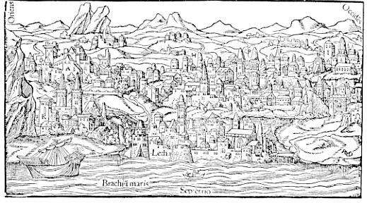
- The rapid advancement of sixteenth-century map-making, fostered by the rise of printing, the recent great discoveries, and advances in geometry and navigational instruments, could now produce an image of the world as seen from above. That cartography offered such a bird's eye view of the land is perhaps clearest in the atlases appearing toward the middle of the century, particularly those that offered less abstract, more painterly views of cities. Sebastian Münster's popular Cosmographei, which went through thirty-six editions between 1544 and 1628 presented panoramic views of cities, most of them German.[8] Such an atlas, following Ptolemy's distinction between chorography and geography, was chorographic, because it portrayed detail, whereas the world atlas of Abraham Ortelius (1570) was properly geographic. Such chorographic maps tended to be more painterly and less abstract, and the cities are typically presented from an elevated perspective, implying an impossibly high vantage point from a harbor -- as in Münster's map of Edinburgh (see Figure 1) -- or from a fictitious hill outside of the city. This of course is not to say that such images of cities were a new development in mid-sixteenth-century Europe. As P.D.A. Harvey has shown, a kind of bird's eye view had been employed previously in medieval European city maps -- though not with the accuracy of scale found in later maps. What is perhaps more important is that while there was relatively little map making in Europe during the middle ages, the development and spread of cartography after 1500 was rapid.[9] To whatever degree bird's-eye-view images may have existed prior to the century of "Great Discovery," to whatever degree maps may have informed ancient geographic and chorographic understanding of the world, it is clear that medieval European society understood little about the maps and the possible uses of them.[10]
- The popularity of Münster's atlas was perhaps eclipsed by the significance granted to another, more comprehensive and more truly global chorography of cities. The year 1572 saw the publication of the first of the six volumes of Georg Braun and Franz Hogenberg's Civitates Orbis Terrarum, an extensive work which R.V. Tooley has classed, with Ortelius' geographic atlas and Waghenaer's sea atlas, as one of the three most notable cartographic achievements of the century.[11] Braun and Hogenberg used a number of Münster's maps and, like Münster, used a bird's eye view for most of the maps.[12] In the map of London in Civitates Orbis Terrarum (see Figure 2), a hill -- seemingly connected to the southern edge of Southwark, yet floating unnaturally above it -- occupies the immediate foreground. Situated atop this hill are several denizens of noble or gentry degree and dress who may -- as may the map reader -- look out upon a lofty vista of London stretching from Westminster to the Tower. While this map, which is fairly typical of the other maps in this atlas, is clearly painterly in its representational portrayal of London, it retains its more abstract purpose as a map: demarcating city walls, charting roads and rivers, and labeling the churches and other significant structures within the city.
- At about the same time that this bird's-eye-view mapping was proliferating, paintings of cityscapes were also becoming popular and Flemish landscape painting was developing -- and perhaps enjoying success because of the general sixteenth-century interest in cartography.[13] Such paintings -- as Svetlana Alpers, in "The Mapping Impulse in Dutch Art", has suggested about the tendency of seventeenth-century Dutch landscape painting to present terrain from a bird's eye view -- blur the line between cartography and painting. As Braun and Hogenberg's work raises questions about what is and is not a map, it also implies that even in the more abstract cartography, a map is fundamentally a view from above.
- Understanding how these elevated perspectives work as an instrument of possession suggests a corollary way of reading certain recurrent elements in the accounts of English voyages such as Gilbert's that were compiled by Richard Hakluyt and, later, by Samuel Purchas. To be sure, not all expressions of the view from above are about land acquisition. Robert Burton found relief from melancholy in the printed representations of such views:
Me thinkes it would well please any man to look upon a Geographicall Map . . . Chorographicall, Topographical delineations, to behold, as it were, all the remote Provinces, Townes, Citties of the World . . . . What greater pleasure can there be, than to view those elaborate maps of Ortelius, Mercator, Hondius, &c.? To peruse those books of cities, put out by Braunus and Hogenbergius?[14]Walter Gibson, discussing what he calls the "Olympian perspective" in his study of sixteenth-century Flemish landscape painting, cites Cicero, Lucretius, and Montaigne as all granting something of a philosophic advantage to such elevated perspectives.[15]
- Yet elsewhere this perspective clearly implies a kind of possession. In his recent analysis of the colonial enterprise in Australia, Simon Ryan discusses the explorers' use of elevation, surveillance and "commanding views," asserting that the "explorative gaze is a microform of the divine gaze."[16] Denis Cosgrove, in arguing that development of linear perspective and landscape in fifteenth- and sixteenth-century Europe is "visual ideology," writes that the view point of the bird's-eyes view of cities is, "significantly, high above the city, distant, commanding, uninvolved."[17] While a full consideration of such commanding views is beyond the pale of this study, it may be enough here to recall how Moses is granted a mountain-top vista of the promised land before his death (Deut. 34: 1-4), how Satan tempts Christ with a view from "an exceeding high mountain shewing him all the kingdoms of the world and the glory of them" (Matt. 4: 5-6), or how Marlowe's Faustus is similarly tempted with the prospects Mephistopheles can provide:
So high our dragons soared into the airAlong with the more medieval need to echo the scene of Christ's temptation, Faustus' lines belie a distinctly early modern application of the view from above: the recent atlases and maps now made it possible to hold in one's hands simulacra of the earth and to behold with the eye the kingdoms of the world.
That looking down the earth appeared to me
No bigger than my hand in quantity --
There did we view the kingdoms of the world
And what might please mine eye I there beheld. (3.1.71-3)
- In Arthur Barlow's 1584 report of the first voyage to Virginia, Barlow writes that just after the ceremony of possession,
We passed from the Sea side, towardes the toppes of those hils next adjoyning, being but of meane heigth, and from thence wee behelde the Sea on both waies. This lande laye stretching it selfe to the West, which after wee founde to be but an Island of twentie leagues long, and above six miles broade. Under the banke or hill, whereon we stoode, we behelde the vallies replenished with goodly Cedar trees . . . . This Island had many goodly woods, full of Deere, Conies, Hares and Fowle, even in the middest of Summer, in incredible aboundance.[18]The elevated perspective allows Barlow to make two different though related observations: to behold and describe the local geography and, as he begins to assess and enumerate the land's potential commodities, to outline what might be held or possessed.
- When Humphrey Gilbert was lost in a shipwreck returning from his Newfoundland voyage, Walter Raleigh -- to whom Barlow's account of Virginia was addressed -- pursued and was granted Gilbert's interests in North America. It was not until 1595 that Raleigh himself traveled to the New World in search of more immediate wealth in Guiana than the Virginia colonies could yield. In his report, The Discovery of the Large, Rich, and Beautiful Empire of Guiana (1596), the hill-top perspective leads to a similar, though more literary description of the land:
When we came to the tops of the first hils of the plaines adjoyning to the river, we beheld that wonderful breach of waters which ran down Caroli: and might from that mountain see the river how it ran in three parts above twenty miles off; and there appeared some ten or twelve overfalls in sight, every one as high over the other as a Church-tower.[19]Part of what Raleigh is advertising here and throughout this report are the marvels of Guiana, but he also presents some bit of chorographical reconnaissance and continues by combining his description of topography, flora and fauna with the promise of gold:I never saw a more beautifull countrey, nor more lively prospects, hils so raised here and there over the valleys, the river winding into divers branches, the plaines adjoyning without bush or stubble, all faire greene grass, the ground of hard sand easy to march on, either for horse or foote, the deere crossing in every path, the birdes towards the evening singing on every tree with a thousand severall tunes, cranes and herons of white, crimson, and carnation pearching in the river's side, the aire fresh with a gentle Easterly wind, and every stone that we stouped to take up, promised either golde or silver by his complexion.[20]The association of elements in this passage reveals the amalgam of Raleigh's interests in Guiana -- beauty, conquest, gold -- and these are shown in a sustained panoramic description. From the seemingly ethereal vantage of the hilltops we pan from the waterfalls, to the valleys and rivers, to the land suited for military movement, to the paradisiacal wildlife, sounds, and air, to the stones on the ground.
- A few decades later these hilltop perspectives in reports from the New World appear somewhat less pictorial and more starkly topographical. In John Guy's journal of his voyage to Newfoundland in 1612, his discovery party goes to "the top of a very high hill, to take full view of the bay of Placentia, and all the countrey about." Because fog "hindred the prospecte," Guy must remain on the hill overnight until clearer weather allows a precise view and record to be taken of the local geography: "the western side of the bay of Placentia was seene to lie W. WSW. & SWBW, & SW. About 10 leagues of theare was ane open into the maine sea, noe land appearing, in which sound theare weare two small Ilandes in a righte line."[21]
- What recurs in these travelers' tales is an inscription of the surveillant gaze from above. The manner of inscription is varied. It may be the lush and vivid representational pictures created here by Barlow and Raleigh, in the manner of Braun and Hogenberg. It may also include the more abstract elements of cartography, a perspective of the land from ninety degrees, more in the manner of Gerard Mercator's projection of the world upon a grid of equivalent rectangles. This latter perspective, suggested somewhat by the harsh geometry of Guy's description, appears most clearly in voyage accounts as references to longitude and latitude.
- That the world could be plotted along horizontal and vertical lines was an idea that spread through Europe with the rediscovery of Ptolemaic geography during the late-fourteenth- and fifteenth-centuries. Samuel Y. Edgerton, Jr. argues that the rediscovery of this grid system, first used by Greek and Roman empires, profoundly affected the European construction of space, changing art, architecture, and cities, as well as changing representations and conceptions of the world.[22] Ptolemy's grid depended not on divine revelation, writes Edgerton, but
on the quantifying eye of the human observer, who was now able to imagine himself detached from the world as if looking at it on a stage. Indeed, the viewer of Ptolemy's map was privileged to see the world as did the gods themselves from their lofty vantage on Mount Olympus.[23]Like the perspective gained by Gilbert in St. John's, or the sight advantage, Alpers notes, that artists achieved by climbing towers in seventeenth-century Holland,[24] the ruled map presented a privileged view of the land. That this grid works as a technique of authority and possession would seem to be corroborated by Edgerton's assertion that the Ptolemaic longitude and latitudes -- endorsed by Pope Pius II in the 1460's -- made conceivable the extension of European Christian empire to all parts of the earth.[25]
- The almost instant authority of these lines was perhaps most clearly demonstrated when, a year after Columbus' first voyage, Pope Alexander VI drew, as Hakluyt wrote it, "a lyne of partition from one Pole unto another passinge a hundred leagues westwarde of the Iles of Azores" granting the unknown territory east of the line to Portugal and that west to Spain. That such simple partition met some degree of resistance is suggested by the story, which Hakluyt relates, of the Portuguese boy, who upon meeting the men who had come "to devide the worlde with the Emperor . . . tooke up his shirte behinde and shewed them his buttocks, sayenge unto them, Draw your Lyne throughe the middest of this place."[26]
- Sixteenth-century discussion of the import of these lines of longitude and latitude -- decidedly more dry than either the assertions of Edgerton or the Portuguese boy -- was restricted primarily to the explanations found in geography and navigational books on how to use navigational instruments and geometry to understand global positions on a ruled sea chart.[27] The most important of these navigational manuals was Martin Cortes' Breve Compendio de la Sphera y de Arte de Navegar, written in 1545. In 1561 this work was appeared in England as The Arte of Navigation, translated by Richard Eden, an early advocate of new world exploration who had also translated the portion from Münster's Cosmographei on the new found lands in 1553. Among many other navigational techniques, Cortes' book offers instructions for composing and copying sea charts, showing the success of the Ptolemaic grid in supplanting the traditional grid-free portolan sea chart. For copying and reducing a chart, or "card," by use of the lines of latitude and longitude, Cortes instructs the navigator to draw two sets of equidistant lines at right angles, which "shall devide all the superficiall parte of the Carde into perfect squares or quadratures," allowing a more precise representation of earth or sea.
- The value of these ruled lines was central to William Cuningham's The Cosmographical Glasse (1559). Cuningham's dialogue on "the pleasant Principles" of cosmography, geography, and hydrography relies heavily on such grid delineators as the equinoctial line, the meridian, the tropic and polar circles, and the lines of longitude and latitude. Following the instructions on how to make a map of England by use of parallel intersecting lines, we are told, (see Figure 3: Grid map of England showing global coordinates from Cuningham's Cosmographical Glasse) "that the whole worke doth chieflye depende uppon the Meridian Line," its consequent lines of longitudes; "by Paralleles of Climates" and the lines of latitude. Furthermore, these instructions would allow one to "drawe a Carde for Spaine, Fraunce, Germany, Italye, Greece, or any perticuler region" -- a prospect which prompts Cuningham's scholar to laud, "Oh how precious a Jewell is this, it may rightyly be called a Cosmographical Glasse, in which we may behold the diversitie of countries: natures of people, innumerable formes of Beastes, Foules Fishes, Trees, Frutes, Stremes, & Meatalles."[28] That the gaze through the precious cosmographical glass promised more than a simple increased accuracy in navigation is something that was not lost on Cuningham, who notes in his preface the "manifold benefites" -- civil, religious, physiological, intellectual -- to be gained by the study of maps. Cuningham also claims that ancient empires understood the value of cartography, explaining that Alexander would display maps of lands marked for conquest
for all men to behold, whereby the Capitaines did forsee, and seke out where was the easiest places to arrive, and Souldiors allured with the commodities of the Countries, were made the willinger to the thinge. This was it which gat him so many victories, and made his so great a Conqeror. This was it which obteined the Romanes their Fame, more then ther force and strength.[29]While much of The Cosmographical Glasse is concerned with lines latitude and longitude, Cuningham includes a bird's-eye-view map of Norwich as an example, he says, of chorography (see Figure 4: Map of Norwich from Cuningham's Cosmographical Glasse). Upon the foregrounded hill stand two figures -- presumably Cuningham's two dialogists -- with a commanding view of the city, engaged in measuring the details of the city.
- In the decades that followed Cuningham's Cosmographical Glasse and Eden's translation of The Arte of Navigation, the realization among those conceiving and begetting a British empire was that to rule the world, the world must first be ruled. Precise charting and effective colonizing were integral activities -- and something that the Spanish had already recognized. During the effort to map New Spain in the 1570's, Barbara Mundy has noted, questionnaires filled out by Spanish officers in the New World were particularly concerned with measurements of longitude and latitude, demonstrating what Mundy calls "the inescapable print of Ptolemy's geographical grid."[30] During the English effort to establish new world colonies, the reports of voyages that appear in Hakluyt's Principal Navigations contain an increasing number of references to global coordinates as the sixteenth-century passes.
- The literature that Hakluyt compiled concerning the Muscovy Company's 1580 voyage to find the northeast passage to China illustrate this increased importance of cartographic information. In his instructions to shipmasters Arthur Pet and Charles Jackman, William Burrough notes the importance of keeping accurate time with the sand-glass (a measurement used for estimating longitude), and directs them to "diligently observe the latitude" and to draw on charts such coastal features as bays, rivers, hills, and woods: "These orders if you diligently observe, you may thereby perfectly set downe in the plats, that I have given you, your whole travell, and description of your discovery, which is a thing that will be chiefly expected at your hands."[31]
- Since the purpose of the voyage was the discovery of a new route to China, one might readily expect this privileging of cartographic information, but Burrough's instructions for surveillance nonetheless betrays an important shift in the purpose of such voyages. The search here is not for gold -- a quest of a more monarchical and feudal character (yet one that explorers like Martin Frobisher and Raleigh were ostensibly still pursuing at the time) but rather for more grid coordinates and topographical and hydrographical description -- a project more beneficial to nascent mercantile capitalism. The ensuing report from the unsuccessful search for a northeast passage anticipates the style of later voyage writing in that it contains less narrative and more figures, measurement, and a diligent record of latitudinal and longitudinal coordinates.
- Another document that appears in Hakluyt's Principal Navigations concerning this expedition is a brief note of advice from John Dee. Dee was a pioneer in arithmetical navigation, a mathematical advisor for the Muscovy company, and one of the early proponents of English colonization.[32] He believed in a navigable northeast passage and had three years earlier talked with Abraham Ortelius about such a passage during the cartographer's visit to England.[33] Most of Dee's brief note contains directions for finding the supposed passage -- expressed almost entirely by reference to distances, longitude and latitude. Once arrived in China, Dee advises in the final paragraph, Pet and Jackman "may to great good purpose bee occupied . . . in discreet view . . . noting downe the situation of the Cities within land, &c. and ever assaying to come by some charts or maps of the countrey."[34] That some of this cartographic reconnaissance was to be done "in discreet view" implies that such information was regarded as a kind of state secret. Indeed sixteenth-century unpublished maps were often highly guarded, and in his Discourse of Western Planting Richard Hakluyt complained that the primary reason for Ortelius' 1577 visit to England was "but to prye and looke into the secretes of ffrobishers voyadge."[35]
- As cartographers like Ortelius and Mercator continued to publish maps and atlases reflecting more current discoveries, the power that might be said to reside in any particular map was disseminated to those who, as John Dee said in his preface to a 1570 translation of Euclid's Elements of Geometrie, "liketh, loveth, getteth, and useth, Mappes Chartes, & Geographicall Globes."[36] Despite Hakluyt's concern over the prying into Frobisher's findings, secrecy did not necessarily amplify the power and authority of a map.[37] Indeed, Hakluyt's elder cousin, also named Richard Hakluyt, instructed Pet and Jackman to give the Chinese khan a copy of Ortelius' atlas, "for it would be to a Prince of marveilous account," and to
Take with you the mappe of England set out in faire colours, one of the biggest sort I meane, to make shew of your country from whence you come. And also the large Mappe of London to make shew of your Citie. And let the river be drawen full of Ships of all sorts, to make the more shew of your great trade and traffike in trade of merchandize.[38]Here we see the map working not so much as a tool of surveillance, but as a signifier of power -- in this case, as the river is to "be drawen full of ships," as a signifier of commercial power. This is not the only account of a divulgence of the new cosmographical knowledge with non-Europeans. In 1607, when John Smith, in a somewhat desperate effort to impress a very hostile army of Virginia natives, used a compass as a model of a globe to explain the "roundnesse of the earth" and the "greatness of the Land and Sea," he reports, "they all stood as amazed with admiration."[39]
- The apparent wizardry of navigational instruments and world maps that may have awed the khan of China or the chief of the Virginia Algonquins is only the most overt manner that cartographic representations acted as signifiers of power. As we have seen with the suggestion that the Thames be "drawen full of ships," the inscription of the cartographic gaze allows "fictions" -- a term that Francis Drake used to decry sixteenth-century mapping errors, but one that, in contemporary map history and theory, would serve to define how maps reveal some element of invention, some trace of their ideological motivation, in their reflection of the world.[40] These fictions -- which appear most conspicuously as cartouches, inscriptions, royal or noble arms, the naming of physical features and cities, or decorative conventions like ships or sea monsters -- would also include the bird's-eye-view and the grid coordinates; after all, the implied hill-side vantage points in the maps of Braun and Hogenberg were often non-existent; the world is not etched with parallel and perpendicular lines, nor for that matter is north "up" -- and much has been written recently about how such cartographic fictions work as a mode of power.[41]
- The surveillant gaze, however, while no doubt serving as an image of authority when it has become inscribed, printed, and viewed by Dee's map-reading public, is already a strategy of power before publication. While the military advantage provided from such a view is ancient, the very act of surveying the land was in sixteenth-century England becoming inseparable from the issue of authority and ownership as power increasingly emanated from ownership of land. In 1583, Edward Worsop wrote, "The common people are in great fear when survey is to be made of their land."[42] John Norden, who was also making outstanding county maps of England, published in 1607 The Surveyors Dialogue, a book which, as well as offering technical instructions for executing accurate estate surveys, also attempts to appease what seems to have been a common mistrust of surveys. Norden's surveyor, who seeks the cooperation of a wary farmer, explains that -- though many farmers "are so wise in their own conceit, as they thinke them fooles that give any assistance unto this worke"[43] -- it is to the just benefit of both the landlord and tenant to have the land accurately surveyed. In the prefatory "Epistle to the Reader," Norden argues that "a due, true, and exact view and survey" of the tenants' land -- which included not only a drawing, but an estimation of its revenue, of "the Quantities, and Qualities of Land" -- is needed to guarantee that the "Lord be not abused, nor the tenants wronged."
- Richard Helgerson writes that it was just such surveyors and map-makers as Norden who, through their mapping of England during the reign of Elizabeth and James, began to dissolve the bond that Norden nonetheless maintains in his prefatory letter: the service and respect a landlord owes a king. Maps, says Helgerson, allowed the English to "see in a way never before possible the country -- both county and nation -- to which they belonged and at the same time showed royal authority -- or at least its insignia -- to be a merely ornamental adjunct to that country. Maps thus opened a conceptual gap between the land and its ruler, a gap that would eventually span battlefields."[44] He further suggests that the cartographic representation of a space, i.e. England, changed the perception and understanding of that space sufficiently to contribute to the subversion of monarchical power and to the establishment of a more modern construction of power in that space.[45]
- How might Helgerson's thesis contribute to an understanding of the effect of the mapping of the New World that was being done at the same time?[46] By analogy, it would seem appropriate to posit that if the maps of England created an image of nationhood, the maps of the world -- particularly those of potential colonial territory -- would have created an image of empire. But perhaps a more fundamental point in understanding the relation of cartography and the beginnings of English empire is that maps -- the inscribed gaze of authority if you will -- invent and sometimes reinvent an idea of space and place. If we look at some of the tracts that served as propaganda for early English colonization, it becomes clear that these are not merely the written records of a voyage, but multi-faceted descriptions of the land which work to create as sharp an image of place as might be possible in a print medium.
- It was because George Peckham was seeking contributions for an expedition to continue Humphrey Gilbert's colonization efforts that he wrote in 1583 his True Report of the late discoveries, which later appeared in Hakluyt's 1589 Principal Navigations. While Peckham's book contains some chapters devoted to proving the moral and legal grounds for such colonization (the savages must be Christianized; the English have precedence in north Atlantic America), most of it is concerned with describing a potentially profitable colony. The first chapter, containing the possession ceremony discussed earlier, retells Edward Hayes' account -- also published by Hakluyt in 1589 -- of what Hayes called the "exact discovery into the bowels of those maine, ample, and vast countreys, extended infinitely into the North from 30 degress, or rather from 25 degress of Septentionall atitude."[47] For Peckham as well colonization was to be considered throughout this larger range of latitude -- essentially the entire Atlantic coast of North America -- "betweene the degrees of 30. and 60. of septentrionall latitude." Within this range of latitude, Peckham writes,
by computation Astronomicall and Cosmographicall are doubtles to be founde, all thinges that be necessarie profitable, or delectable for mans life. The climate mylde and temperate, neither too hotte nor too colde, so that under the cope of heaven there is not any where to be founde a more convenient place to plant and inhabite in.[48]Peckham's assertion that the suitability of this territory for western planting can be affirmed by "computation Astronomicall and Cosmographical" reveals the extent to which sixteenth-century geography was capable of shaping an image of a distant place.
- Climate was a particular concern in the literature on Newfoundland, and when Richard Whitborne -- who claimed to have been present during Gilbert's possession ceremony of 1583 -- published his Discourse and Discovery of New-Found-Land (1620) to encourage colonization, he made a direct claim for Newfoundland's temperate climate based on latitudinal analogy:
It is to be seene by the Cosmographers Maps, and well approved, that the New-found-land is an Iland, bordering upon the Continent of America, from which it is divided by the Sea: so farre distant, as England is from the neerest part of France, and lieth between 46 and 53 degrees North-latitude: It is as spacious as Ireland . . . and neere halfe the way between Ireland and Virginia. I shall not neede to commend the wholesome temperature of that Countrey, seeing the greatest part thereof lieth above foure degress neere to the South, then any part of England doth.[49]Describing the "situation" of the land was a fairly conventional tactic in the propaganda for New World colonies, and some degree of geographical knowledge would have been expected from the community of readers for which such propaganda was intended. Whitborne assumes that the reader can visualize the size of Ireland, the distance to Virginia, and has studied the "Cosmographers maps."
- Such map-literate references were common by the 1620's when new efforts to colonize Newfoundland yielded other works of propaganda.[50] What distinguishes this later wave of Newfoundland propaganda is that the reports strive for a more clearly cartographic depiction of the island than they did in the 1580's. In Whitborne's work, latitude is used to relate size, distance and climate, and, as seen earlier, John Guy's 1612 bird's-eye perspective of Placentia Bay presents a more precise and geometric landscape than similar reports from earlier colonialist writers.
- That cartographic elements are more clearly imbedded in the reports on the New World within a few decades after the work of Gilbert, Peckham, Dee, and the Hakluyts to encourage western planting underscores the importance of such elements in creating a place for colonization that was imaginable, identifiable, and readily located. One of the more renowned early propaganda tracts is Thomas Harriot's A Briefe and True Report of the Newfoundland of Virginia, first published in 1588, and later in 1590 with the inclusion of Theodor De Bry's engravings of John White's paintings. Two of these engravings were based on White's map of Virginia -- a map informed by the land surveying techniques of Thomas Harriot and which was by far the most accurate and valuable map of the region for many decades.[51] That Harriot -- perhaps best known because of Marlowe's alleged blasphemous quip that "one Heriots being Sir W. Raleghs man" can do more than Moses, who "was but a Jugler" -- should be both the author of this propaganda for American colonization and a brilliant mathematician who applied his science to surveying and navigation highlights the necessary links between two such undertakings. Harriot, who had first been employed by Raleigh as a mathematician -- and was praised by Hakluyt as being "a man preeminent" in mathematics and navigation -- wrote the navigational instructions for Barlow's 1584 Virginia voyage, and later served Raleigh in Ireland, probably even conducting surveys and making maps of Raleigh's extensive colonial plantations there.[52] Yet Harriot's work for Raleigh on the 1585 voyage to Virginia entailed both his work as a colonial surveyor and, with the writing of his Briefe and True Report, as a propagandist. Here the functions of the surveillant map-maker and the place-depicting, chorographic propagandist mesh neatly.
- Cartographic elements in A Briefe and True Report are most clearly seen in John White's depiction of the natives which comprises the fourth and most ethnographic section of Harriot's book. Very much like Braun and Hogenberg, White -- or possibly De Bry -- often places his specimen denizens in the foreground on a raised plateau or hill with a peopled landscape visible in the background. For most of these images, proportion suggests that the natives and their way of dressing is of greater importance than the topography. Nonetheless, of the twenty-one illustrations of these Algonquin people and their culture, only eight do not provide something like an elevated view, and all five of the images of the Picts -- which were appended to show comparison between ancient northern Britons and contemporary Americans -- are drawn in this manner.
- While the similarity between these images and those in Braun and Hogenberg prompts questions about the ethnological elements in their Civitates and in Münster's Cosmographei, it also demonstrates the influence of cartography on Harriot, White and De Bry. Two of these illustrations -- the only two, besides the actual maps, that do not isolate for study a native body or an activity -- are of towns. The picture of "The Towne of Pomeiooc" (see Figure 5: Map of "Towne of Pomeioc" from Harriot's Briefe and True Report) provides just enough foreground -- a few small but close-up, indigenous plants drawn in White's naturalist manner -- to suggest the hilltop view. The village itself is walled with large poles, has but one entrance, and contains some eighteen structures, some of which are labeled in a manner similar to their European counterparts. The "Towne of Secota" is similarly drawn and labeled and both pictures are filled in with depictions of Algonquin religious and economic or agricultural activity -- Hakluyt's chief concerns in his Briefe and True Report and his rationale for colonizing these people.
- This surveillant eye implied by these illustrations encompasses more than the strict concerns of the cosmographer. Like Norden's surveyor, Harriot and White were to report not just the quantities, but the qualities of the land. That the agronomic elements were drawn in and labeled was of a piece with the whole of pattern of A Briefe and True Report . The first two sections of the book enumerate and detail the "Marchantable Commodities" -- any useful and profitable plants, animals, or minerals -- that were found in Virginia. As a work of propaganda for mercantile trading, it is not surprising that it should contain an accounting of everything from sassafras to sturgeon. What is perhaps more interesting is how in so many reports from the New World this listing of natural resources is so closely connected to the function of the map-maker. White and Harriot, Pet and Jackman, and Gilbert's Newfoundland reconnaissance party were all to map land and simultaneously assess commodities. As we have already seen, even in the more casual hilltop surveillance of the land, like Barlow's or Raleigh's, the perspective provokes comments on the land's riches.
- The cataloging of commodities and the description of the people clearly contribute to the establishment of a sense of place in these reports. It would be tempting to broaden the definition somewhat and say every page of Harriot's A Briefe and True Report is a "map," an inscribed representation of place. John Smith seemed to be marketing to those who loved, bought, and used maps when he titled his 1612 report on the Jamestown colonization efforts, A Map of Virginia, although the work contained but one map and many more pages of prose description of, as the subtitle stated, the Countrey, the Commodities, People, Government and Religion. There is in fact a surprising lack of actual maps in Hakluyt's Principal Navigations, although the author acknowledges in his preface that "it would bee expected as necessarie, that the descriptions of so many parts of the world would farre more easily be conceived of the Readers, by adding Geographicall, and Hydrographicall tables thereunto." The only map that does appear in the four volumes of Principal Navigations is a fairly poor general map of the world.[53]
- What was finally most important for the promoters of western planting was that the world could, to use Hakluyt's words, "easily be conceived." Conceived is a term full of meaning in this context, as Hakluyt had earlier encouraged Raleigh that his "bride," Virginia, "will shortly bring forth new and most abundant offspring, such as will delight you and yours, and cover with disgrace and shame those who have so often dared rashly and impudently to charge her with barreness."[54] Thomas Abbay, of the Jamestown colony, knew the importance of being able to "cousider, to conceave, & apprehend Virginia, which might be, or breed us a second India."[55]
- Richard Whitborne coupled this feminine sexualizing of the New World with geographic land forms in his assertion that the peninsulas on the eastern side of Newfoundland resemble extended arms: "New-found-land (as it is here truly described) is little inferior to any other for the commodoties thereof; and lies, as it were, with open armes towards England, offering it selfe to be imbraced, and inhabited by us."[56] This anthropomorphic image presupposes a concept of the geographic situation of the island, a concept engendered by the voyage accounts written by colonial propagandists and published by Hakluyt, as well as by recently published maps and atlases.
- That the literature served fundamentally the same purpose as the new maps was implied by George Peckham who, the first to remark the "arms" of Newfoundland, claimed that the island
dooth (as it were with arme advaunced) above the climats both of Spayne and Fraunce, stretche out it selfe towardes England onelie. In manner praying our ayde and helpe, as it is not onelie set foorth in Mercators generall Mappe, but it is also founde to be true by the discovery of our nation.[57]The New World this time is not offspring or breeder, but supplicant -- and a very particular supplicant, asking for English deliverance only. The surveillant view from above provided by the cartographer's map and the English voyager's report constructs America as a place not only ideal for profitable colonies but in need of English and Christian salvation.
- At the very least we must regard the cartographer's chart of the territory and the writer's survey of land, commodities, and people as printed texts which allowed the English to conceive of colonial territory -- conceive in colonial territory -- by making it familiar, making it known.[58] To construct a locus through prose descriptions of terrain, plants, animals, and people is only a different mode than map-making provided of making it possible to behold the kingdoms of the world. The images that are simultaneously captured and created by these charts and by these reports are only the beginning of other English appropriations from and constructions of the new found land.
The initial research for this essay was conducted in Ann Arbor during the 1992 National Endowment for the Humanities Summer Seminar, "Inventing the New World", directed by Steven Mullaney. I thank both the NEH and Professor Mullaney for their help.
Works Cited1. Steven Greenblatt suggests that possession ceremonies in the New World involved either a theatrical element -- a symbolic gesture or act such as turf digging, for instance -- for the present native audience, or a legalistic element -- a reading of documents -- for a distant European audience. Marvelous Possessions: The Wonders of the New World (Chicago: U of Chicago P, 1991) 55-60. Gilbert's possession -- and even more his "discovery" -- is a something of an anomaly because Newfoundland was clearly already frequented by many Europeans. [Back]
2. Sir George Peckham A True Report of the late discoveries, and possession, taken in the right of the Crowne of England, of the Newfound Landes (1583) English Experience 341 (Amsterdam: Theatrum Orbis Terrarum ; Da Capo Press, 1971) 2. [Back]
3. D.B. Quinn, ed. The Voyages and Colonising Enterprises of Sir Humphrey Gilbert. 2 Vols. Hakluyt Society. (Repr. Liechtenstein: Kraus, 1967) 444. [Back]
4. Michel Foucault, Power/Knowledge: Selected Interviews and Other Writing ed. Colin Gordon (Brighton: Harvester, 1986) 155. [Back]
5. For discussion of Elizabethan theatricality and power see, for a beginning, Greenblatt's Shakespearean Negotiations (46-7, 64-5) and Mullaney's The Place of the Stage (96-7). Greenblatt also offers a bibliographical note on this subject (175 n. 61). [Back]
6. Gillian T. Cell ed. Newfoundland Discovered: English Attempts at Colonization, 1610-1630 (London: Hakluyt Society, 1982) 106. [Back]
7. Todorov suggests that it is writing, language inscribed, that gave the advantage to the Spaniards in the conquest of Mexico. See also Michel De Certeau's discussion of function of writing in New World colonialism (215-18) and Jose Rabasa's "Columbus and the New Scriptual Economy of the Renaissance." [Back]
8. R Oehme, Introduction to Münster's 1550 Cosmographei (Amsterdam: Theatrum Orbis Terrarum, 1968) v. [Back]
9. P.D.A. Harvey, The History of Cartography, Ed. J.B. Harley and David Woodward (Vol. 1. Chicago: U of Chicago P, 1987) 464-65. [Back]
10. J.B. Harley and David Woodward eds., Cartography in Prehistoric, Ancient, and Medieval Europe and the Mediterranean vol. 1 of The History of Cartography (Chicago: U of Chicago P, 1987) 508-09. [Back]
11. Georg Braun and Remigius Hogenberg, Civitates Orbis Terrarum (Antwerp: Apud Philippum Gallecum, 1572) Repr. and with an introduction by R.A. Skelton (Cleveland: World, 1966) v. [Back]
12. Taylor observes that in instructions to a surveyor, Thomas Bavin, in the plans for a 1582 Gilbert expedition which was deferred until 1593, "he was instructed to make on his map the location of every natural product likely to prove of economic value" ("Instructions to a Colonial Surveyor in 1582," 61). Taylor adds that it is likely that Bavin did the survey work around St. John's the following year. [Back]
13. In his introduction to a facsimile edition of Braun and Hogenberg, R.A. Skelton identifies four different perspectival modes used in Civitates, though three of these combine either a hilltop perspective, a more elevated bird's-eye-view, or what Skelton calls a "map view" in which the vertical perspective of a ground-plan is "enriched by delineations of detail in bird's eye view or elevation" (xi). For my purposes, I have not made a distinction among maps drawn in bird's-eye view, the elevation perspective, or those using the "map-view" and will use the terms interchangeably as all suggest, in varying degrees, the view from above. [Back]
14. Burton, The Anatomy of Melancholy, 2: 86-7. [Back]
15. Walter Gibson, 57-8. Gibson argues that Renaissance interest in cartography and geography influenced the favor that Flemish landscape painting enjoyed (49). See Kagan on the growth of cityscapes (115). [Back]
16. Ryan's book, The Cartographic Eye: How Explorers Saw Australia (Cambridge: Cambridge UP. 1996), which I discovered while revising this essay, is informed, I would like to think, by similar theoretical concerns about European cartography, perspective, colonization, and ethnography as my essay. He writes, "The explorative gaze is a mastery of space. This book is about this gaze, about its discursive construction in the journals and its meaning within the context of the colonial enterprise"(6). [Back]
17. Cosgrove, "Prospect, Perspective, and the Evolution of the Landscape Idea." Transactions of the Institute of British Geographers 10 (1985): 47,51. [Back]
18. D.B. Quinn, The Roanoke Voyages: 1584-1590 2 vols. (Hakluyt Society, repr. Liechtenstein: Kraus, 1967) 96. [Back]
19. Hakluyt, The Principal Navigations, Voyages, Traffiques & Discoveries of the English Nation (Glasgow: James MacLehose, 1904) 10: 403-4. [Back]
20. Principal Navigations 10: 404. [Back]
21. Newfoundland Discovered 73. [Back]
22. Edgerton's argument on grid and cartography appears in two chapters of his Renaissance Rediscovery of Linear Perspective and in his essay "From Mental Matrix." Alpers, arguing against Edgerton's link between Albertian perspective in painting and Ptolemaic grids, says that it is in Northern Europe, not Italy, "that maps and pictures are reconciled, and the results are clear in the great and unprecedented production of mapped pictures, the landscapes and city views" (70). It may be enough to say here that both forms, Edgerton's grid and Alpers' elevated perspective, are offering a view from above that offers a radical departure from the earlier, medieval way of representing and imagining the surface of the world. [Back]
23. Renaissance Rediscovery of Linear Perspective 38. [Back]
24. Svetlana Alpers, The Art of Describing: Dutch Art in the Seventeenth Century (London: J. Murray, 1983) 81. [Back]
25. Renaissance Rediscovery of Linear Perspective 48. [Back]
26. Taylor, ed., The Original Writings & Correspondence of the Two Richard Hakluyts, 2 Vols. Hakluyt Society Reprint (Liechtenstein: Kraus, 1967) 306. [Back]
27. See David W. Waters, The Art of Navigation in England in Elizabethan and Early Stuart Times, (London: Hollis and Carter, 1958), especially the early chapters, for a discussion of the importance of these sixteenth-century navigation books. [Back]
28. Cosmographical Glasse 120. [Back]
29. Cosmographical Glasse. [Back]
30. Barbara Mundy, The Mapping of New Spain: Indigenous Cartography and the Maps of the Relaciones Geográficas (Chicago: U of Chicago P, 1996) 30. [Back]
31. Principal Navigations 3:260-61. [Back]
32. Taylor writes that Dee was one of "the brains of the early colonizing movement" -- among whom were also included the two Richard Hakluyts, Humphrey Gilbert, and George Peckham (The Original Writings & Correspondence of the Two Richard Hakluyts 21-2). See also Waters, 525. [Back]
33. The Original Writings & Correspondence of the Two Richard Hakluyts, 19, 12. [Back]
34. Principal Navigations 3: 263. [Back]
35. See Harley's "Maps, Knowledge, Power" for a brief consideration of cartography and secrecy in the sixteenth-century (284). [Back]
36. Waters says that Cuningham's Cosmographical Glasse "brought the subject [of cosmography] from the scholars closet to the shelves of the gentry and the desks of the merchants" (99). No doubt, the publication of atlases and maps would have done the same. [Back]
37. Helgerson observes that the influence of geographical knowledge on power in the sixteenth-century was different for each European nation. Forms of Nationhood 357. [Back]
38. Principal Navigations 3:272. [Back]
39. Captain John Smith, The Complete Works ed. Philip L. Barbour (Chapel Hill: U of North Carolina P, 1986) 2:147. [Back]
40. Drake quoted in Helen Wallis, "The Cartography of Drake's Voyage." Sir Francis Drake and the Famous Voyage, 1577-1580. Ed. Norman J. Thrower. Berkeley: U of California P, 1984: 159. [Back]
41. See especially the work of J.B. Harley, as well as Denis Wood's The Power of Maps, and any number of recent articles in the journal Cartographica . [Back]
42. Quoted in Taylor, "The Surveyor" 131. [Back]
43. Norden, The Surueyors Dialogue (London: Hugh Astley, 1607) 24. [Back]
44. Forms of Nationhood 114. [Back]
45. Steven Mullaney treats the shifts from older, medieval to modern -- more abstract and quantitative -- understandings of space in Elizabethan England in his reading of John Stow's Survey of London (especially 15-20). [Back]
46. Helgerson does in fact devote a chapter to Richard Hakluyt's impact on English nationhood, though the function of cartography is not an issue here as it is in his reading of maps of England. [Back]
47. Quinn, Voyages 385. [Back]
48. Quinn, Voyages 447. [Back]
49. Newfoundland Discovered 116-7. [Back]
50. John Mason's A Briefe Discourse of the Newfoundland with the Situation, temperture, and commodoties there-of (1620, reprinted in Newfoundland Discovered) uses many of the same geographical comparisons to describe Newfoundland, though he points out that in America"any place under the same Parallel of another place in Europe, is as cold as those places which are situated in 12. or 13. degrees to the North wards therof"(97) -- no doubt a more accurate assessment of the Newfoundland climate, but one which nonetheless too simply relies on latitude. [Back]
51. Quinn, Roanoke 58. [Back]
52. Taylor, Writings 366. See Shirley's biography for discussion of Harriot's relationship with Raleigh and his work as a surveyor in Virginia and Ireland. [Back]
53. See Quinn and Skelton's discussion of this map in their introduction to Principal Navigations (xlviii-l). [Back]
54. Taylor, Writings, 367. Raleigh would later say"Guiana is a countrey that hath yet her maydenhead"(Hakluyt 10:428). For discussion of Raleigh, Guiana and gender, see Montrose, "The Work of Gender in the Discourse of Discovery." Representations 33 (1991): 1-41. [Back]
55. Philip L. Barbour, ed., The Jamestown Voyages Under the First Charter, 1606-1609 Hakluyt Society (Cambridge: Cambridge UP, 1969) 2: 331. [Back]
56. Newfoundland Discovered 111. [Back]
57. Quinn, Voyages, 448. [Back]
58. One of the clear effects of Harriot's Briefe and True Report was to make Virginia seem familiar, even English. Thus from the description of "Leekes differing little from ours in England" (17) to De Bry's Europeanized Algonquins, to the inclusion of images of Picts, "to showe how that the Inhabitants of the great Bretannie have bin in times past as savage as those of Virginia" (75), the Report domesticates this new land and people. [Back]
- Alpers, Svetlana. The Art of Describing: Dutch Art in the Seventeenth Century. London: J. Murray, 1983.
- Barbour, Philip L. ed. The Jamestown Voyages Under the First Charter, 1606-1609. Hakluyt Society. Cambridge: Cambridge UP, 1969.
- Braun , Georg and Remigius Hogenberg, Civitates Orbis Terrarum. 1572. Cleveland: World, 1966.
- Burton, Robert. The Anatomy of Melancholy. London: Chatto and Windus, 1924.
- Cell, Gillian T., ed. Newfoundland Discovered: English Attempts at Colonization, 1610-1630. London: Hakluyt Society, 1982.
- Cosgrove, Denis. "Prospect, Perspective, and the Evolution of the Landscape Idea." Transactions of the Institute of British Geographers 10 (1985): 47, 51.
- Edgerton, Samuel Y. Jr. Renaissance Rediscovery of Linear Perspective. New York: Basic Books, 1975.
- Foucault, Michel. Power/Knowledge: Selected Interviews and Other Writing . Ed. Colin Gordon. Brighton: Harvester, 1986.
- Greenblatt, Steven. Marvelous Possessions: The Wonders of the New World. Chicago: U of Chicago P, 1991.
- Hakluyt, Richard. The Principal Navigations, Voyages, Traffiques & Discoveries of the English Nation. Glasgow: James MacLehose, 1904.
- Harley, J.B. and David Woodward ,eds. Cartography in Prehistoric, Ancient, and Medieval Europe and the Mediterranean vol. 1 of The History of Cartography. Chicago: U of Chicago P, 1987.
- Harvey, P.D.A. The History of Cartography. Vol. 1. Ed. J.B. Harley and David Woodward. Chicago: U of Chicago P, 1987.
- Helgerson, Richard. Forms of Nationhood:the Elizabethan Writing of England. U of Chicago P, 1992.
- Mason, John. A Briefe Discourse of the Newfoundland with the Situation, temperture, and commodoties there-of. 1620. Reprinted Newfoundland Discovered.
- Mundy, Barbara. The Mapping of New Spain: Indigenous Cartography and the Maps of the Relaciones Geográficas. Chicago: U of Chicago P, 1996.
- Norden. The Surueyors Dialogue. London: Hugh Astley, 1607.
- Oehme, R. "Introduction." Cosmographei. 1550. Amsterdam: Theatrum Orbis Terrarum, 1968.
- Peckham , Sir George. A True Report of the late discoveries, and possession, taken in the right of the Crowne of England, of the Newfound Landes (1583) The English Experience 341. Amsterdam: Theatrum Orbis Terrarum; Da Capo Press, 1971.
- Quinn, D.B., ed. The Voyages and Colonising Enterprises of Sir Humphrey Gilbert. 2 Vols. Hakluyt Society Reprint. Liechtenstein: Kraus, 1967.
- ---. The Roanoke Voyages: 1584-1590. 2 vols. Hakluyt Society Reprint. Liechtenstein: Kraus, 1967.
- Ryan, Simon. The Cartographic Eye: How Explorers Saw Australia. Cambridge: Cambridge UP. 1996.
- Smith, Captain John. The Complete Works. Ed. Philip L. Barbour. Chapel Hill: U of North Carolina P, 1986.
- Taylor, E.G.R., ed. The Original Writings & Correspondence of the Two Richard Hakluyts, 2 Vols. Hakluyt Society Reprint. Liechtenstein: Kraus, 1967.
- Waters, David W. The Art of Navigation in England in Elizabethan and Early Stuart Times. London: Hollis and Carter, 1958.
- Wallis, Helen. "The Cartography of Drake's Voyage." Sir Francis Drake and the Famous Voyage, 1577-1580. Ed. Norman J. Thrower. Berkeley: U of California P, 1984.
© 1998-, R.G. Siemens (Editor, EMLS).